You are here: Home > Network List > US - United States National Seismic Network Stations List
> Station MSO Missoula, Montana, USA > Earthquake Result Viewer
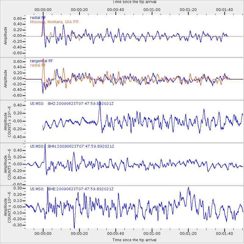
MSO Missoula, Montana, USA - Earthquake Result Viewer
*The percent match for this event was below the threshold and hence no stack was calculated.
| Earthquake location: |
Near East Coast Of Honshu, Japan |
| Earthquake latitude/longitude: |
38.8/142.4 |
| Earthquake time(UTC): |
2009/06/23 (174) 07:37:17 GMT |
| Earthquake Depth: |
37 km |
| Earthquake Magnitude: |
5.7 MB, 5.0 MS, 5.6 MW, 5.6 MW |
| Earthquake Catalog/Contributor: |
WHDF/NEIC |
|
| Network: |
US United States National Seismic Network |
| Station: |
MSO Missoula, Montana, USA |
| Lat/Lon: |
46.83 N/113.94 W |
| Elevation: |
1264 m |
|
| Distance: |
70.9 deg |
| Az: |
44.919 deg |
| Baz: |
306.582 deg |
| Ray Param: |
$rayparam |
*The percent match for this event was below the threshold and hence was not used in the summary stack. |
|
| Radial Match: |
66.49537 % |
| Radial Bump: |
400 |
| Transverse Match: |
63.35215 % |
| Transverse Bump: |
400 |
| SOD ConfigId: |
2648 |
| Insert Time: |
2010-03-05 02:20:46.071 +0000 |
| GWidth: |
2.5 |
| Max Bumps: |
400 |
| Tol: |
0.001 |
|
Signal To Noise
| Channel | StoN | STA | LTA |
| US:MSO: :BHN:20090623T07:47:59.892021Z | 5.2315063 | 2.0535404E-7 | 3.925333E-8 |
| US:MSO: :BHE:20090623T07:47:59.892021Z | 1.8240566 | 1.0757855E-7 | 5.8977637E-8 |
| US:MSO: :BHZ:20090623T07:47:59.892021Z | 2.9024444 | 1.9933941E-7 | 6.867984E-8 |
| Arrivals |
| Ps | |
| PpPs | |
| PsPs/PpSs | |


