You are here: Home > Network List > IN - National Seismic Network of India Stations List
> Station PBA Port Blair, Andaman and Nicobar Islands, India > Earthquake Result Viewer
PBA Port Blair, Andaman and Nicobar Islands, India - Earthquake Result Viewer
| Earthquake location: |
Vanuatu Islands |
| Earthquake latitude/longitude: |
-16.1/167.3 |
| Earthquake time(UTC): |
2016/04/28 (119) 19:33:27 GMT |
| Earthquake Depth: |
35 km |
| Earthquake Magnitude: |
7.0 MO |
| Earthquake Catalog/Contributor: |
NEIC PDE/NEIC ALERT |
|
| Network: |
IN National Seismic Network of India |
| Station: |
PBA Port Blair, Andaman and Nicobar Islands, India |
| Lat/Lon: |
11.66 N/92.74 E |
| Elevation: |
79 m |
|
| Distance: |
78.8 deg |
| Az: |
285.655 deg |
| Baz: |
109.113 deg |
| Ray Param: |
0.049372576 |
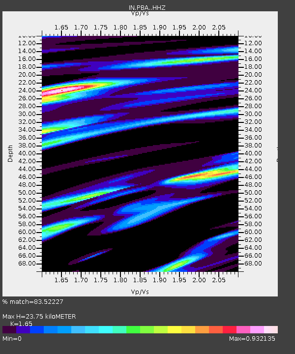
| Estimated Moho Depth: |
23.75 km |
| Estimated Crust Vp/Vs: |
1.65 |
| Assumed Crust Vp: |
6.32 km/s |
| Estimated Crust Vs: |
3.83 km/s |
| Estimated Crust Poisson's Ratio: |
0.21 |
|
| Radial Match: |
83.52227 % |
| Radial Bump: |
392 |
| Transverse Match: |
65.16697 % |
| Transverse Bump: |
400 |
| SOD ConfigId: |
7422571 |
| Insert Time: |
2019-04-22 11:56:35.707 +0000 |
| GWidth: |
2.5 |
| Max Bumps: |
400 |
| Tol: |
0.001 |
|

Signal To Noise
| Channel | StoN | STA | LTA |
| IN:PBA: :HHZ:20160428T19:44:53.419983Z | 37.479134 | 6.960673E-6 | 1.857213E-7 |
| IN:PBA: :HHN:20160428T19:44:53.419983Z | 2.7902074 | 5.1260184E-7 | 1.8371462E-7 |
| IN:PBA: :HHE:20160428T19:44:53.419983Z | 7.5804877 | 1.9272186E-6 | 2.5423412E-7 |
| Arrivals |
| Ps | 2.5 SECOND |
| PpPs | 9.7 SECOND |
| PsPs/PpSs | 12 SECOND |


