You are here: Home > Network List > TA - USArray Transportable Network (new EarthScope stations) Stations List
> Station A21K Barrow, AK, USA > Earthquake Result Viewer
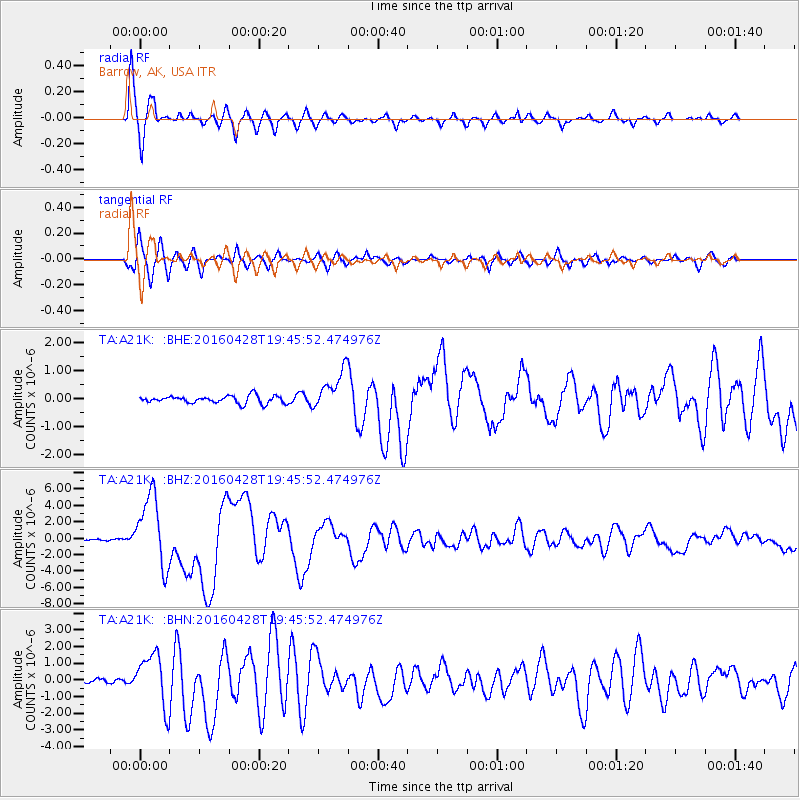
A21K Barrow, AK, USA - Earthquake Result Viewer
*The percent match for this event was below the threshold and hence no stack was calculated.
| Earthquake location: |
Vanuatu Islands |
| Earthquake latitude/longitude: |
-16.1/167.3 |
| Earthquake time(UTC): |
2016/04/28 (119) 19:33:27 GMT |
| Earthquake Depth: |
35 km |
| Earthquake Magnitude: |
7.0 MO |
| Earthquake Catalog/Contributor: |
NEIC PDE/NEIC ALERT |
|
| Network: |
TA USArray Transportable Network (new EarthScope stations) |
| Station: |
A21K Barrow, AK, USA |
| Lat/Lon: |
71.32 N/156.62 W |
| Elevation: |
577 m |
|
| Distance: |
90.6 deg |
| Az: |
10.929 deg |
| Baz: |
214.45 deg |
| Ray Param: |
$rayparam |
*The percent match for this event was below the threshold and hence was not used in the summary stack. |
|
| Radial Match: |
96.492004 % |
| Radial Bump: |
358 |
| Transverse Match: |
92.106636 % |
| Transverse Bump: |
400 |
| SOD ConfigId: |
7422571 |
| Insert Time: |
2019-04-22 11:58:07.220 +0000 |
| GWidth: |
2.5 |
| Max Bumps: |
400 |
| Tol: |
0.001 |
|
Signal To Noise
| Channel | StoN | STA | LTA |
| TA:A21K: :BHZ:20160428T19:45:52.474976Z | 42.75658 | 4.3591085E-6 | 1.0195175E-7 |
| TA:A21K: :BHN:20160428T19:45:52.474976Z | 11.643835 | 1.5531608E-6 | 1.3338911E-7 |
| TA:A21K: :BHE:20160428T19:45:52.474976Z | 6.204735 | 8.7056753E-7 | 1.4030697E-7 |
| Arrivals |
| Ps | |
| PpPs | |
| PsPs/PpSs | |


