You are here: Home > Network List > TA - USArray Transportable Network (new EarthScope stations) Stations List
> Station G05D Wamic, OR, USA > Earthquake Result Viewer
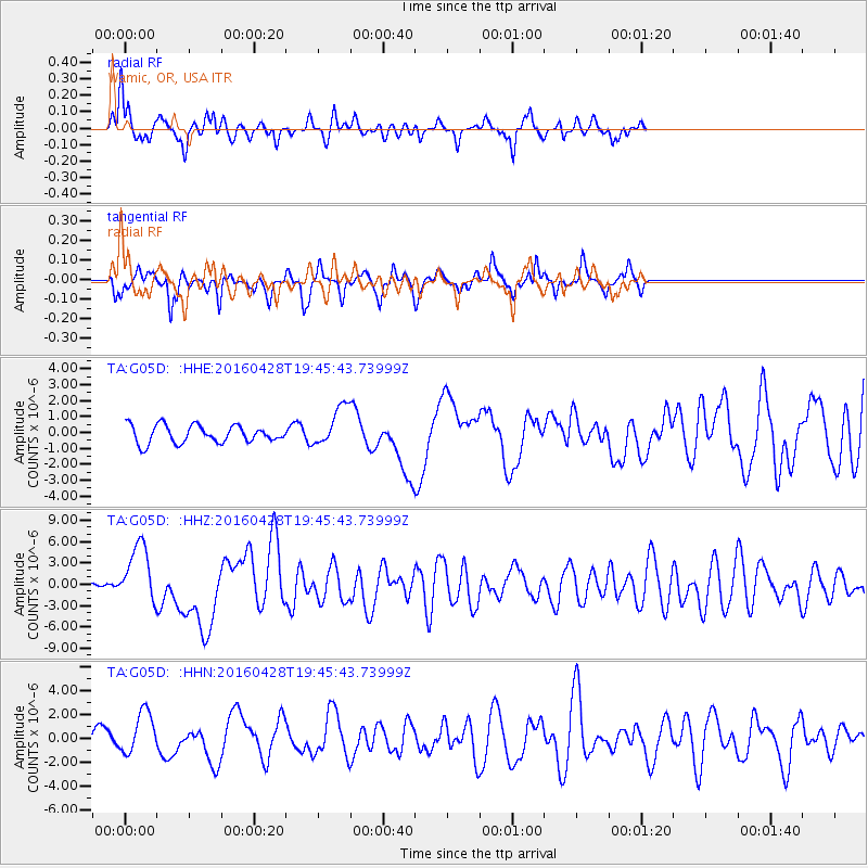
G05D Wamic, OR, USA - Earthquake Result Viewer
*The percent match for this event was below the threshold and hence no stack was calculated.
| Earthquake location: |
Vanuatu Islands |
| Earthquake latitude/longitude: |
-16.1/167.3 |
| Earthquake time(UTC): |
2016/04/28 (119) 19:33:27 GMT |
| Earthquake Depth: |
35 km |
| Earthquake Magnitude: |
7.0 MO |
| Earthquake Catalog/Contributor: |
NEIC PDE/NEIC ALERT |
|
| Network: |
TA USArray Transportable Network (new EarthScope stations) |
| Station: |
G05D Wamic, OR, USA |
| Lat/Lon: |
45.24 N/121.32 W |
| Elevation: |
592 m |
|
| Distance: |
88.7 deg |
| Az: |
42.032 deg |
| Baz: |
245.648 deg |
| Ray Param: |
$rayparam |
*The percent match for this event was below the threshold and hence was not used in the summary stack. |
|
| Radial Match: |
74.92173 % |
| Radial Bump: |
347 |
| Transverse Match: |
68.730095 % |
| Transverse Bump: |
361 |
| SOD ConfigId: |
7422571 |
| Insert Time: |
2019-04-22 11:58:14.530 +0000 |
| GWidth: |
2.5 |
| Max Bumps: |
400 |
| Tol: |
0.001 |
|
Signal To Noise
| Channel | StoN | STA | LTA |
| TA:G05D: :HHZ:20160428T19:45:43.73999Z | 13.402344 | 4.18613E-6 | 3.123431E-7 |
| TA:G05D: :HHN:20160428T19:45:43.73999Z | 2.2050343 | 1.7667343E-6 | 8.012276E-7 |
| TA:G05D: :HHE:20160428T19:45:43.73999Z | 2.7967384 | 1.5270213E-6 | 5.4600076E-7 |
| Arrivals |
| Ps | |
| PpPs | |
| PsPs/PpSs | |


