You are here: Home > Network List > TA - USArray Transportable Network (new EarthScope stations) Stations List
> Station K24K Donnelly Dome, AK, USA > Earthquake Result Viewer
K24K Donnelly Dome, AK, USA - Earthquake Result Viewer
| Earthquake location: |
Vanuatu Islands |
| Earthquake latitude/longitude: |
-16.1/167.3 |
| Earthquake time(UTC): |
2016/04/28 (119) 19:33:27 GMT |
| Earthquake Depth: |
35 km |
| Earthquake Magnitude: |
7.0 MO |
| Earthquake Catalog/Contributor: |
NEIC PDE/NEIC ALERT |
|
| Network: |
TA USArray Transportable Network (new EarthScope stations) |
| Station: |
K24K Donnelly Dome, AK, USA |
| Lat/Lon: |
63.80 N/145.78 W |
| Elevation: |
724 m |
|
| Distance: |
87.4 deg |
| Az: |
18.924 deg |
| Baz: |
224.623 deg |
| Ray Param: |
0.043282356 |
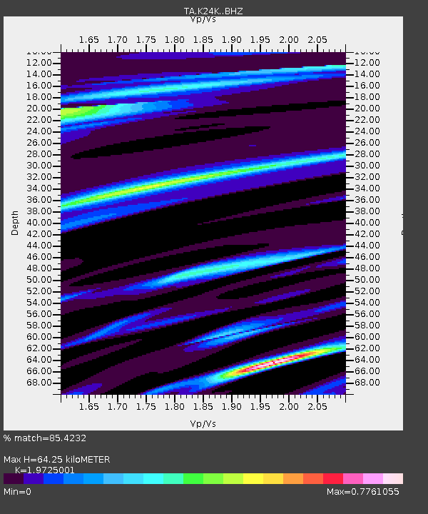
| Estimated Moho Depth: |
64.25 km |
| Estimated Crust Vp/Vs: |
1.97 |
| Assumed Crust Vp: |
6.566 km/s |
| Estimated Crust Vs: |
3.329 km/s |
| Estimated Crust Poisson's Ratio: |
0.33 |
|
| Radial Match: |
85.4232 % |
| Radial Bump: |
351 |
| Transverse Match: |
60.915115 % |
| Transverse Bump: |
400 |
| SOD ConfigId: |
7422571 |
| Insert Time: |
2019-04-22 11:58:44.912 +0000 |
| GWidth: |
2.5 |
| Max Bumps: |
400 |
| Tol: |
0.001 |
|

Signal To Noise
| Channel | StoN | STA | LTA |
| TA:K24K: :BHZ:20160428T19:45:37.625Z | 16.364494 | 4.4868893E-6 | 2.741844E-7 |
| TA:K24K: :BHN:20160428T19:45:37.625Z | 2.3788643 | 7.8799616E-7 | 3.3124888E-7 |
| TA:K24K: :BHE:20160428T19:45:37.625Z | 2.062801 | 1.1631126E-6 | 5.638512E-7 |
| Arrivals |
| Ps | 9.7 SECOND |
| PpPs | 28 SECOND |
| PsPs/PpSs | 38 SECOND |


