You are here: Home > Network List > TA - USArray Transportable Network (new EarthScope stations) Stations List
> Station M22K Willow, AK, USA > Earthquake Result Viewer
M22K Willow, AK, USA - Earthquake Result Viewer
| Earthquake location: |
Vanuatu Islands |
| Earthquake latitude/longitude: |
-16.1/167.3 |
| Earthquake time(UTC): |
2016/04/28 (119) 19:33:27 GMT |
| Earthquake Depth: |
35 km |
| Earthquake Magnitude: |
7.0 MO |
| Earthquake Catalog/Contributor: |
NEIC PDE/NEIC ALERT |
|
| Network: |
TA USArray Transportable Network (new EarthScope stations) |
| Station: |
M22K Willow, AK, USA |
| Lat/Lon: |
61.75 N/150.12 W |
| Elevation: |
57 m |
|
| Distance: |
84.6 deg |
| Az: |
18.852 deg |
| Baz: |
220.761 deg |
| Ray Param: |
0.045340087 |
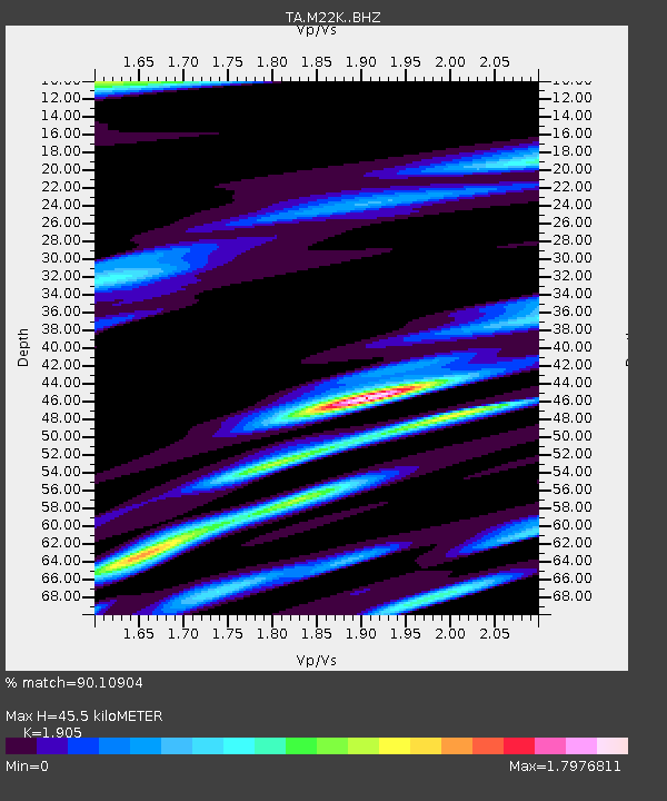
| Estimated Moho Depth: |
45.5 km |
| Estimated Crust Vp/Vs: |
1.90 |
| Assumed Crust Vp: |
6.302 km/s |
| Estimated Crust Vs: |
3.308 km/s |
| Estimated Crust Poisson's Ratio: |
0.31 |
|
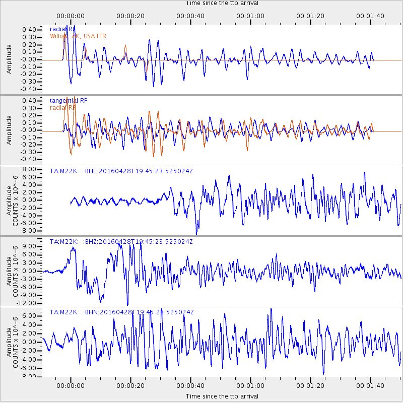
| Radial Match: |
90.10904 % |
| Radial Bump: |
400 |
| Transverse Match: |
87.849594 % |
| Transverse Bump: |
400 |
| SOD ConfigId: |
7422571 |
| Insert Time: |
2019-04-22 11:58:51.633 +0000 |
| GWidth: |
2.5 |
| Max Bumps: |
400 |
| Tol: |
0.001 |
|
Signal To Noise
| Channel | StoN | STA | LTA |
| TA:M22K: :BHZ:20160428T19:45:23.525024Z | 17.916636 | 5.726999E-6 | 3.19647E-7 |
| TA:M22K: :BHN:20160428T19:45:23.525024Z | 3.0057023 | 2.074892E-6 | 6.903186E-7 |
| TA:M22K: :BHE:20160428T19:45:23.525024Z | 4.1176457 | 2.1572903E-6 | 5.239135E-7 |
| Arrivals |
| Ps | 6.7 SECOND |
| PpPs | 21 SECOND |
| PsPs/PpSs | 27 SECOND |


