You are here: Home > Network List > WY - Yellowstone Wyoming Seismic Network Stations List
> Station YHH Holmes Hill, YNP, WY, USA > Earthquake Result Viewer
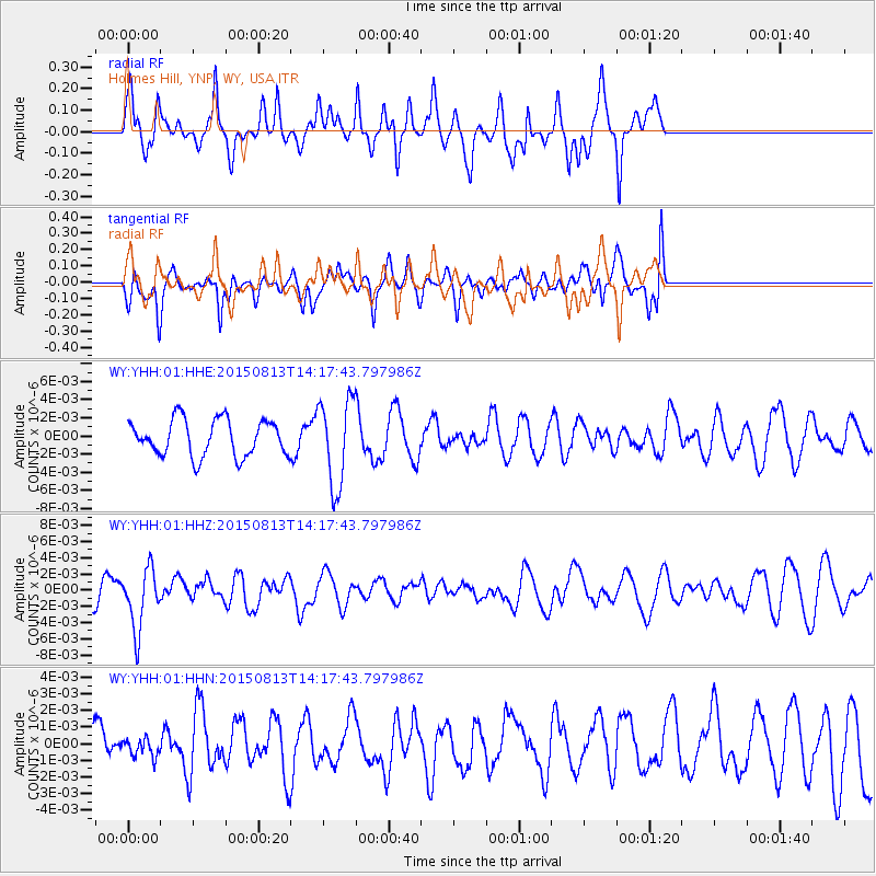
YHH Holmes Hill, YNP, WY, USA - Earthquake Result Viewer
*The percent match for this event was below the threshold and hence no stack was calculated.
| Earthquake location: |
New Ireland Region, P.N.G. |
| Earthquake latitude/longitude: |
-3.9/152.9 |
| Earthquake time(UTC): |
2015/08/13 (225) 14:04:58 GMT |
| Earthquake Depth: |
137 km |
| Earthquake Magnitude: |
5.6 MB |
| Earthquake Catalog/Contributor: |
NEIC PDE/NEIC ALERT |
|
| Network: |
WY Yellowstone Wyoming Seismic Network |
| Station: |
YHH Holmes Hill, YNP, WY, USA |
| Lat/Lon: |
44.79 N/110.85 W |
| Elevation: |
2717 m |
|
| Distance: |
97.2 deg |
| Az: |
45.518 deg |
| Baz: |
271.591 deg |
| Ray Param: |
$rayparam |
*The percent match for this event was below the threshold and hence was not used in the summary stack. |
|
| Radial Match: |
70.14674 % |
| Radial Bump: |
382 |
| Transverse Match: |
67.02776 % |
| Transverse Bump: |
400 |
| SOD ConfigId: |
1085051 |
| Insert Time: |
2015-08-27 14:35:48.214 +0000 |
| GWidth: |
2.5 |
| Max Bumps: |
400 |
| Tol: |
0.001 |
|
Signal To Noise
| Channel | StoN | STA | LTA |
| WY:YHH:01:HHZ:20150813T14:17:43.797986Z | 2.4844968 | 3.74257E-9 | 1.5063693E-9 |
| WY:YHH:01:HHN:20150813T14:17:43.797986Z | 0.31019375 | 5.4114996E-10 | 1.7445548E-9 |
| WY:YHH:01:HHE:20150813T14:17:43.797986Z | 2.3911362 | 4.7493245E-9 | 1.986221E-9 |
| Arrivals |
| Ps | |
| PpPs | |
| PsPs/PpSs | |


