You are here: Home > Network List > UW - Pacific Northwest Regional Seismic Network Stations List
> Station UMAT Pilot Rock, OR, USA > Earthquake Result Viewer
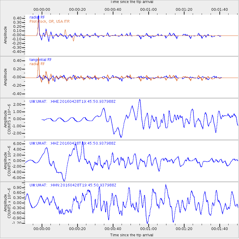
UMAT Pilot Rock, OR, USA - Earthquake Result Viewer
*The percent match for this event was below the threshold and hence no stack was calculated.
| Earthquake location: |
Vanuatu Islands |
| Earthquake latitude/longitude: |
-16.1/167.3 |
| Earthquake time(UTC): |
2016/04/28 (119) 19:33:27 GMT |
| Earthquake Depth: |
35 km |
| Earthquake Magnitude: |
7.0 MO |
| Earthquake Catalog/Contributor: |
NEIC PDE/NEIC ALERT |
|
| Network: |
UW Pacific Northwest Regional Seismic Network |
| Station: |
UMAT Pilot Rock, OR, USA |
| Lat/Lon: |
45.29 N/118.96 W |
| Elevation: |
1318 m |
|
| Distance: |
90.3 deg |
| Az: |
42.652 deg |
| Baz: |
247.322 deg |
| Ray Param: |
$rayparam |
*The percent match for this event was below the threshold and hence was not used in the summary stack. |
|
| Radial Match: |
94.99877 % |
| Radial Bump: |
334 |
| Transverse Match: |
87.90944 % |
| Transverse Bump: |
400 |
| SOD ConfigId: |
7422571 |
| Insert Time: |
2019-04-22 11:59:59.298 +0000 |
| GWidth: |
2.5 |
| Max Bumps: |
400 |
| Tol: |
0.001 |
|
Signal To Noise
| Channel | StoN | STA | LTA |
| UW:UMAT: :HHZ:20160428T19:45:50.937988Z | 11.917889 | 2.9285839E-6 | 2.4573006E-7 |
| UW:UMAT: :HHN:20160428T19:45:50.937988Z | 0.9818176 | 2.4302955E-7 | 2.4753024E-7 |
| UW:UMAT: :HHE:20160428T19:45:50.937988Z | 4.868185 | 8.8523007E-7 | 1.8183985E-7 |
| Arrivals |
| Ps | |
| PpPs | |
| PsPs/PpSs | |


