You are here: Home > Network List > 7A - Mid-Atlantic Geophysical Integrative Collaboration Stations List
> Station CABN Riverton, West Virginia USA > Earthquake Result Viewer
CABN Riverton, West Virginia USA - Earthquake Result Viewer
| Earthquake location: |
Northern East Pacific Rise |
| Earthquake latitude/longitude: |
10.3/-103.8 |
| Earthquake time(UTC): |
2016/04/29 (120) 01:33:38 GMT |
| Earthquake Depth: |
10 km |
| Earthquake Magnitude: |
6.8 MWP, 6.9 MI |
| Earthquake Catalog/Contributor: |
NEIC PDE/NEIC COMCAT |
|
| Network: |
7A Mid-Atlantic Geophysical Integrative Collaboration |
| Station: |
CABN Riverton, West Virginia USA |
| Lat/Lon: |
38.72 N/79.44 W |
| Elevation: |
910 m |
|
| Distance: |
35.7 deg |
| Az: |
33.48 deg |
| Baz: |
223.955 deg |
| Ray Param: |
0.077064686 |
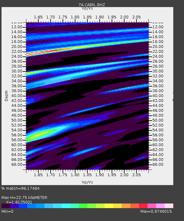
| Estimated Moho Depth: |
22.75 km |
| Estimated Crust Vp/Vs: |
1.61 |
| Assumed Crust Vp: |
6.159 km/s |
| Estimated Crust Vs: |
3.819 km/s |
| Estimated Crust Poisson's Ratio: |
0.19 |
|
| Radial Match: |
96.17464 % |
| Radial Bump: |
229 |
| Transverse Match: |
79.20922 % |
| Transverse Bump: |
400 |
| SOD ConfigId: |
7422571 |
| Insert Time: |
2019-04-22 12:03:16.377 +0000 |
| GWidth: |
2.5 |
| Max Bumps: |
400 |
| Tol: |
0.001 |
|

Signal To Noise
| Channel | StoN | STA | LTA |
| 7A:CABN: :BHZ:20160429T01:40:06.610009Z | 18.97183 | 2.2006593E-6 | 1.1599615E-7 |
| 7A:CABN: :BHN:20160429T01:40:06.610009Z | 7.97311 | 1.0325051E-6 | 1.2949842E-7 |
| 7A:CABN: :BHE:20160429T01:40:06.610009Z | 7.613699 | 9.769554E-7 | 1.2831548E-7 |
| Arrivals |
| Ps | 2.4 SECOND |
| PpPs | 8.9 SECOND |
| PsPs/PpSs | 11 SECOND |


