You are here: Home > Network List > 7A - Mid-Atlantic Geophysical Integrative Collaboration Stations List
> Station NAZF Center Point, West Virginia USA > Earthquake Result Viewer
NAZF Center Point, West Virginia USA - Earthquake Result Viewer
| Earthquake location: |
Northern East Pacific Rise |
| Earthquake latitude/longitude: |
10.3/-103.8 |
| Earthquake time(UTC): |
2016/04/29 (120) 01:33:38 GMT |
| Earthquake Depth: |
10 km |
| Earthquake Magnitude: |
6.8 MWP, 6.9 MI |
| Earthquake Catalog/Contributor: |
NEIC PDE/NEIC COMCAT |
|
| Network: |
7A Mid-Atlantic Geophysical Integrative Collaboration |
| Station: |
NAZF Center Point, West Virginia USA |
| Lat/Lon: |
39.38 N/80.64 W |
| Elevation: |
0.0 m |
|
| Distance: |
35.6 deg |
| Az: |
31.537 deg |
| Baz: |
221.624 deg |
| Ray Param: |
0.07714567 |
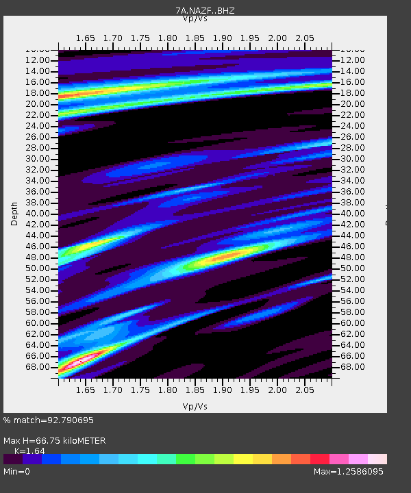
| Estimated Moho Depth: |
66.75 km |
| Estimated Crust Vp/Vs: |
1.64 |
| Assumed Crust Vp: |
6.207 km/s |
| Estimated Crust Vs: |
3.785 km/s |
| Estimated Crust Poisson's Ratio: |
0.20 |
|
| Radial Match: |
92.790695 % |
| Radial Bump: |
285 |
| Transverse Match: |
84.93543 % |
| Transverse Bump: |
400 |
| SOD ConfigId: |
7422571 |
| Insert Time: |
2019-04-22 12:03:24.410 +0000 |
| GWidth: |
2.5 |
| Max Bumps: |
400 |
| Tol: |
0.001 |
|

Signal To Noise
| Channel | StoN | STA | LTA |
| 7A:NAZF: :BHZ:20160429T01:40:05.33001Z | 10.05392 | 2.4450683E-6 | 2.4319553E-7 |
| 7A:NAZF: :BHN:20160429T01:40:05.33001Z | 6.3382325 | 1.1847687E-6 | 1.8692415E-7 |
| 7A:NAZF: :BHE:20160429T01:40:05.33001Z | 7.1801686 | 9.692209E-7 | 1.3498581E-7 |
| Arrivals |
| Ps | 7.4 SECOND |
| PpPs | 26 SECOND |
| PsPs/PpSs | 34 SECOND |


