You are here: Home > Network List > 7A - Mid-Atlantic Geophysical Integrative Collaboration Stations List
> Station WTMN Standardsville, Virginia USA > Earthquake Result Viewer
WTMN Standardsville, Virginia USA - Earthquake Result Viewer
| Earthquake location: |
Northern East Pacific Rise |
| Earthquake latitude/longitude: |
10.3/-103.8 |
| Earthquake time(UTC): |
2016/04/29 (120) 01:33:38 GMT |
| Earthquake Depth: |
10 km |
| Earthquake Magnitude: |
6.8 MWP, 6.9 MI |
| Earthquake Catalog/Contributor: |
NEIC PDE/NEIC COMCAT |
|
| Network: |
7A Mid-Atlantic Geophysical Integrative Collaboration |
| Station: |
WTMN Standardsville, Virginia USA |
| Lat/Lon: |
38.30 N/78.48 W |
| Elevation: |
178 m |
|
| Distance: |
36.0 deg |
| Az: |
34.906 deg |
| Baz: |
225.708 deg |
| Ray Param: |
0.07693755 |
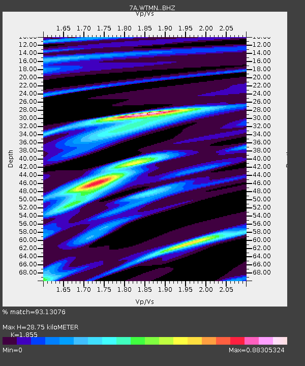
| Estimated Moho Depth: |
28.75 km |
| Estimated Crust Vp/Vs: |
1.86 |
| Assumed Crust Vp: |
6.159 km/s |
| Estimated Crust Vs: |
3.32 km/s |
| Estimated Crust Poisson's Ratio: |
0.30 |
|
| Radial Match: |
93.13076 % |
| Radial Bump: |
194 |
| Transverse Match: |
74.6834 % |
| Transverse Bump: |
400 |
| SOD ConfigId: |
7422571 |
| Insert Time: |
2019-04-22 12:03:29.213 +0000 |
| GWidth: |
2.5 |
| Max Bumps: |
400 |
| Tol: |
0.001 |
|

Signal To Noise
| Channel | StoN | STA | LTA |
| 7A:WTMN: :BHZ:20160429T01:40:08.599999Z | 20.510893 | 1.9423976E-6 | 9.470078E-8 |
| 7A:WTMN: :BHN:20160429T01:40:08.599999Z | 5.9818697 | 7.958101E-7 | 1.3303702E-7 |
| 7A:WTMN: :BHE:20160429T01:40:08.599999Z | 9.756302 | 1.0689913E-6 | 1.09569314E-7 |
| Arrivals |
| Ps | 4.3 SECOND |
| PpPs | 12 SECOND |
| PsPs/PpSs | 17 SECOND |


