You are here: Home > Network List > US - United States National Seismic Network Stations List
> Station LRAL Lakeview Retreat, Alabama, USA > Earthquake Result Viewer
LRAL Lakeview Retreat, Alabama, USA - Earthquake Result Viewer
| Earthquake location: |
Near Coast Of Peru |
| Earthquake latitude/longitude: |
-17.5/-72.1 |
| Earthquake time(UTC): |
2001/07/07 (188) 09:38:43 GMT |
| Earthquake Depth: |
33 km |
| Earthquake Magnitude: |
6.6 MB, 7.3 MS, 7.6 MW, 7.5 ME |
| Earthquake Catalog/Contributor: |
WHDF/NEIC |
|
| Network: |
US United States National Seismic Network |
| Station: |
LRAL Lakeview Retreat, Alabama, USA |
| Lat/Lon: |
33.03 N/87.00 W |
| Elevation: |
130 m |
|
| Distance: |
52.3 deg |
| Az: |
344.131 deg |
| Baz: |
161.906 deg |
| Ray Param: |
0.066802256 |
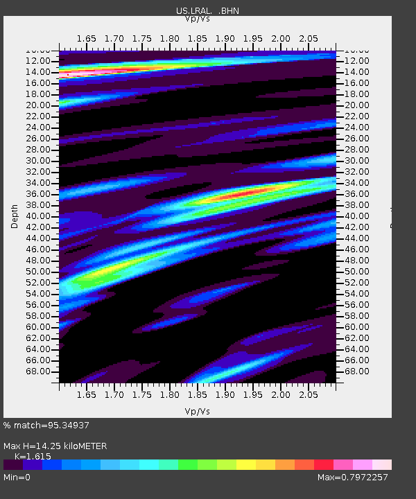
| Estimated Moho Depth: |
14.25 km |
| Estimated Crust Vp/Vs: |
1.62 |
| Assumed Crust Vp: |
6.565 km/s |
| Estimated Crust Vs: |
4.065 km/s |
| Estimated Crust Poisson's Ratio: |
0.19 |
|
| Radial Match: |
95.34937 % |
| Radial Bump: |
400 |
| Transverse Match: |
90.67797 % |
| Transverse Bump: |
400 |
| SOD ConfigId: |
110165 |
| Insert Time: |
2010-03-05 02:30:03.484 +0000 |
| GWidth: |
2.5 |
| Max Bumps: |
400 |
| Tol: |
0.001 |
|
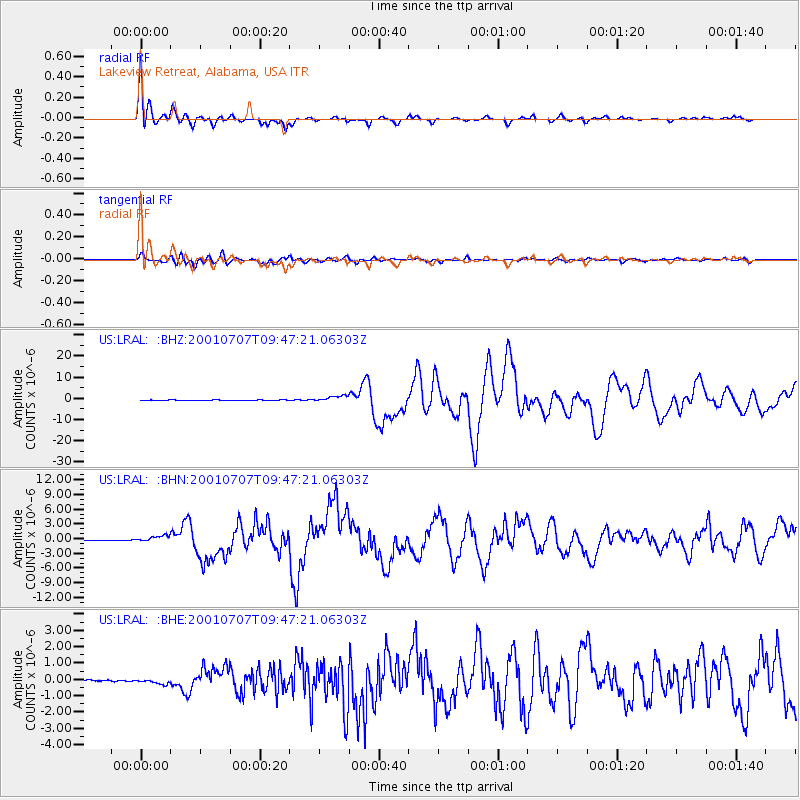
Signal To Noise
| Channel | StoN | STA | LTA |
| US:LRAL: :BHN:20010707T09:47:21.06303Z | 16.173796 | 6.868789E-7 | 4.2468628E-8 |
| US:LRAL: :BHE:20010707T09:47:21.06303Z | 4.0353327 | 1.6106954E-7 | 3.991481E-8 |
| US:LRAL: :BHZ:20010707T09:47:21.06303Z | 17.725689 | 1.4238402E-6 | 8.032637E-8 |
| Arrivals |
| Ps | 1.4 SECOND |
| PpPs | 5.3 SECOND |
| PsPs/PpSs | 6.7 SECOND |


