You are here: Home > Network List > US - United States National Seismic Network Stations List
> Station LRAL Lakeview Retreat, Alabama, USA > Earthquake Result Viewer
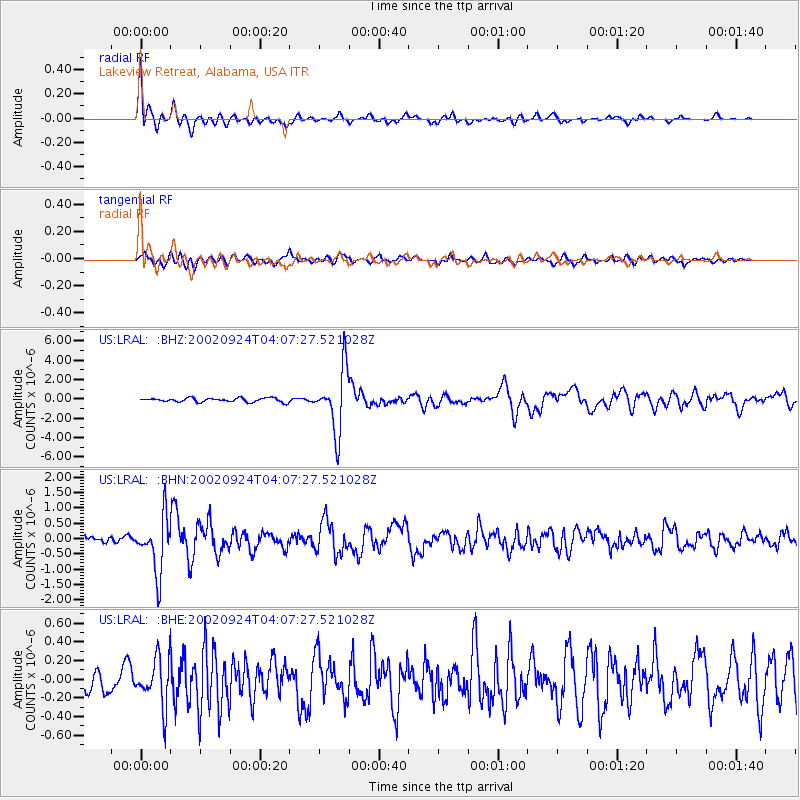
LRAL Lakeview Retreat, Alabama, USA - Earthquake Result Viewer
| Earthquake location: |
San Juan Province, Argentina |
| Earthquake latitude/longitude: |
-31.5/-69.2 |
| Earthquake time(UTC): |
2002/09/24 (267) 03:57:22 GMT |
| Earthquake Depth: |
120 km |
| Earthquake Magnitude: |
6.2 MB, 6.4 MW, 6.3 MW |
| Earthquake Catalog/Contributor: |
WHDF/NEIC |
|
| Network: |
US United States National Seismic Network |
| Station: |
LRAL Lakeview Retreat, Alabama, USA |
| Lat/Lon: |
33.03 N/87.00 W |
| Elevation: |
130 m |
|
| Distance: |
66.4 deg |
| Az: |
343.725 deg |
| Baz: |
163.446 deg |
| Ray Param: |
0.05733202 |
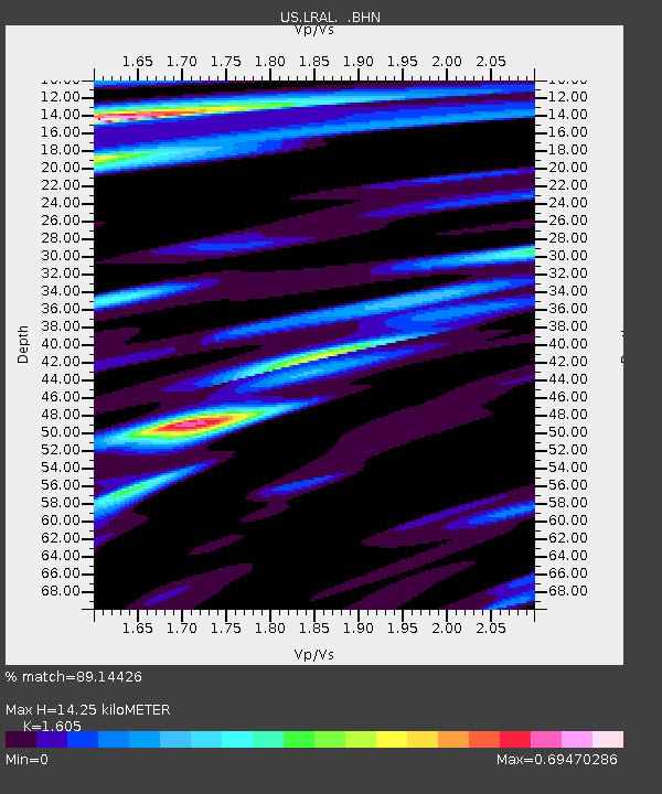
| Estimated Moho Depth: |
14.25 km |
| Estimated Crust Vp/Vs: |
1.61 |
| Assumed Crust Vp: |
6.565 km/s |
| Estimated Crust Vs: |
4.09 km/s |
| Estimated Crust Poisson's Ratio: |
0.18 |
|
| Radial Match: |
89.14426 % |
| Radial Bump: |
400 |
| Transverse Match: |
82.36065 % |
| Transverse Bump: |
400 |
| SOD ConfigId: |
110177 |
| Insert Time: |
2010-03-05 02:30:11.251 +0000 |
| GWidth: |
2.5 |
| Max Bumps: |
400 |
| Tol: |
0.001 |
|
Signal To Noise
| Channel | StoN | STA | LTA |
| US:LRAL: :BHN:20020924T04:07:27.521028Z | 6.5876236 | 9.039702E-7 | 1.3722251E-7 |
| US:LRAL: :BHE:20020924T04:07:27.521028Z | 2.4759169 | 2.5221203E-7 | 1.0186612E-7 |
| US:LRAL: :BHZ:20020924T04:07:27.521028Z | 16.012041 | 3.2019595E-6 | 1.9997198E-7 |
| Arrivals |
| Ps | 1.4 SECOND |
| PpPs | 5.4 SECOND |
| PsPs/PpSs | 6.8 SECOND |


