You are here: Home > Network List > US - United States National Seismic Network Stations List
> Station LRAL Lakeview Retreat, Alabama, USA > Earthquake Result Viewer
LRAL Lakeview Retreat, Alabama, USA - Earthquake Result Viewer
| Earthquake location: |
Western Brazil |
| Earthquake latitude/longitude: |
-7.6/-71.7 |
| Earthquake time(UTC): |
2003/06/20 (171) 06:19:38 GMT |
| Earthquake Depth: |
558 km |
| Earthquake Magnitude: |
6.4 MB, 7.1 MW, 7.0 MW |
| Earthquake Catalog/Contributor: |
WHDF/NEIC |
|
| Network: |
US United States National Seismic Network |
| Station: |
LRAL Lakeview Retreat, Alabama, USA |
| Lat/Lon: |
33.03 N/87.00 W |
| Elevation: |
130 m |
|
| Distance: |
42.9 deg |
| Az: |
341.046 deg |
| Baz: |
157.461 deg |
| Ray Param: |
0.07007362 |
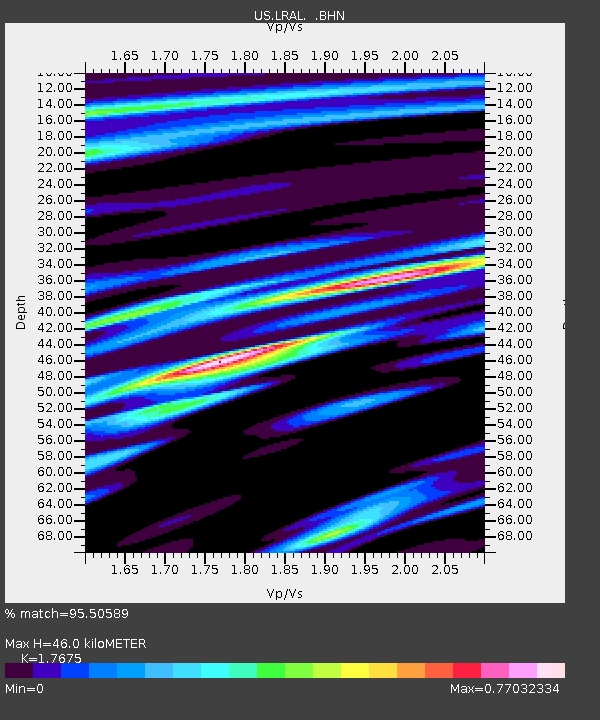
| Estimated Moho Depth: |
46.0 km |
| Estimated Crust Vp/Vs: |
1.77 |
| Assumed Crust Vp: |
6.565 km/s |
| Estimated Crust Vs: |
3.714 km/s |
| Estimated Crust Poisson's Ratio: |
0.26 |
|
| Radial Match: |
95.50589 % |
| Radial Bump: |
400 |
| Transverse Match: |
85.86748 % |
| Transverse Bump: |
400 |
| SOD ConfigId: |
110177 |
| Insert Time: |
2010-03-05 02:31:03.368 +0000 |
| GWidth: |
2.5 |
| Max Bumps: |
400 |
| Tol: |
0.001 |
|

Signal To Noise
| Channel | StoN | STA | LTA |
| US:LRAL: :BHN:20030620T06:26:18.540005Z | 50.924244 | 4.5529405E-6 | 8.940614E-8 |
| US:LRAL: :BHE:20030620T06:26:18.540005Z | 11.591048 | 1.3402719E-6 | 1.1562991E-7 |
| US:LRAL: :BHZ:20030620T06:26:18.540005Z | 51.854656 | 8.420138E-6 | 1.623796E-7 |
| Arrivals |
| Ps | 5.7 SECOND |
| PpPs | 18 SECOND |
| PsPs/PpSs | 24 SECOND |


