You are here: Home > Network List > US - United States National Seismic Network Stations List
> Station LRAL Lakeview Retreat, Alabama, USA > Earthquake Result Viewer
LRAL Lakeview Retreat, Alabama, USA - Earthquake Result Viewer
| Earthquake location: |
Queen Charlotte Islands Region |
| Earthquake latitude/longitude: |
54.7/-134.5 |
| Earthquake time(UTC): |
2003/07/12 (193) 23:01:38 GMT |
| Earthquake Depth: |
20 km |
| Earthquake Magnitude: |
5.3 MB, 5.7 MS, 6.0 MW, 6.0 MW |
| Earthquake Catalog/Contributor: |
WHDF/NEIC |
|
| Network: |
US United States National Seismic Network |
| Station: |
LRAL Lakeview Retreat, Alabama, USA |
| Lat/Lon: |
33.03 N/87.00 W |
| Elevation: |
130 m |
|
| Distance: |
39.5 deg |
| Az: |
103.336 deg |
| Baz: |
317.686 deg |
| Ray Param: |
0.074918054 |
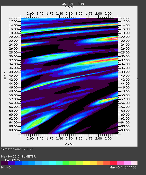
| Estimated Moho Depth: |
20.5 km |
| Estimated Crust Vp/Vs: |
2.10 |
| Assumed Crust Vp: |
6.565 km/s |
| Estimated Crust Vs: |
3.13 km/s |
| Estimated Crust Poisson's Ratio: |
0.35 |
|
| Radial Match: |
92.378876 % |
| Radial Bump: |
400 |
| Transverse Match: |
69.85858 % |
| Transverse Bump: |
400 |
| SOD ConfigId: |
110177 |
| Insert Time: |
2010-03-05 02:31:08.497 +0000 |
| GWidth: |
2.5 |
| Max Bumps: |
400 |
| Tol: |
0.001 |
|

Signal To Noise
| Channel | StoN | STA | LTA |
| US:LRAL: :BHN:20030712T23:08:36.476013Z | 0.9948567 | 6.8138824E-8 | 6.84911E-8 |
| US:LRAL: :BHE:20030712T23:08:36.476013Z | 0.8712551 | 5.7596566E-8 | 6.610758E-8 |
| US:LRAL: :BHZ:20030712T23:08:36.476013Z | 2.2018394 | 2.0006917E-7 | 9.086455E-8 |
| Arrivals |
| Ps | 3.6 SECOND |
| PpPs | 9.1 SECOND |
| PsPs/PpSs | 13 SECOND |


