You are here: Home > Network List > CN - Canadian National Seismograph Network Stations List
> Station A21 St-Andre, QC, CA > Earthquake Result Viewer
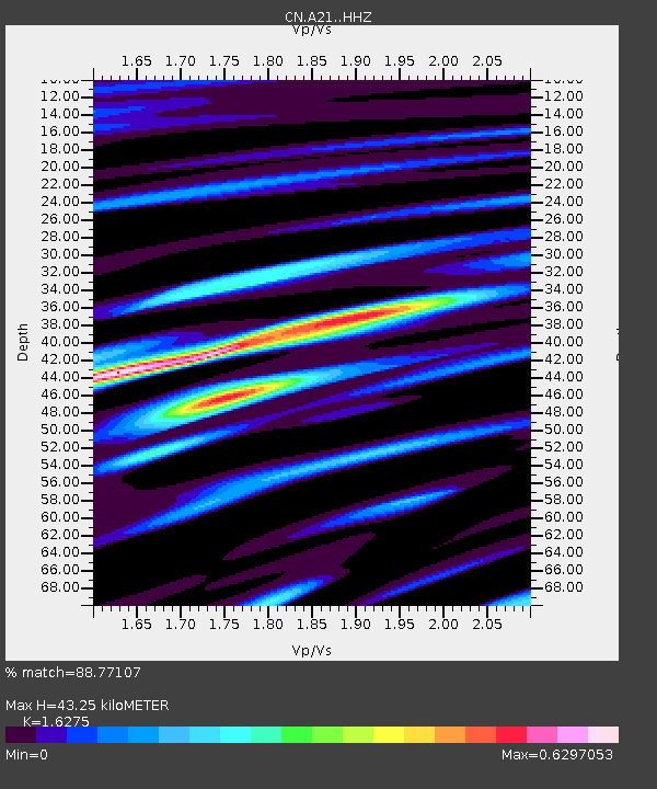
A21 St-Andre, QC, CA - Earthquake Result Viewer
| Earthquake location: |
Northern East Pacific Rise |
| Earthquake latitude/longitude: |
10.3/-103.8 |
| Earthquake time(UTC): |
2016/04/29 (120) 01:33:38 GMT |
| Earthquake Depth: |
10 km |
| Earthquake Magnitude: |
6.8 MWP, 6.9 MI |
| Earthquake Catalog/Contributor: |
NEIC PDE/NEIC COMCAT |
|
| Network: |
CN Canadian National Seismograph Network |
| Station: |
A21 St-Andre, QC, CA |
| Lat/Lon: |
47.70 N/69.69 W |
| Elevation: |
47 m |
|
| Distance: |
47.1 deg |
| Az: |
31.116 deg |
| Baz: |
228.855 deg |
| Ray Param: |
0.07023188 |
| Estimated Moho Depth: |
43.25 km |
| Estimated Crust Vp/Vs: |
1.63 |
| Assumed Crust Vp: |
6.419 km/s |
| Estimated Crust Vs: |
3.944 km/s |
| Estimated Crust Poisson's Ratio: |
0.20 |
|
| Radial Match: |
88.77107 % |
| Radial Bump: |
323 |
| Transverse Match: |
63.54598 % |
| Transverse Bump: |
400 |
| SOD ConfigId: |
7422571 |
| Insert Time: |
2019-04-22 12:05:29.339 +0000 |
| GWidth: |
2.5 |
| Max Bumps: |
400 |
| Tol: |
0.001 |
|

Signal To Noise
| Channel | StoN | STA | LTA |
| CN:A21: :HHZ:20160429T01:41:39.540001Z | 6.7882156 | 1.4017231E-6 | 2.0649361E-7 |
| CN:A21: :HHN:20160429T01:41:39.540001Z | 1.5921472 | 4.950778E-7 | 3.1094976E-7 |
| CN:A21: :HHE:20160429T01:41:39.540001Z | 2.789462 | 5.7520987E-7 | 2.0620816E-7 |
| Arrivals |
| Ps | 4.5 SECOND |
| PpPs | 17 SECOND |
| PsPs/PpSs | 21 SECOND |


