You are here: Home > Network List > CN - Canadian National Seismograph Network Stations List
> Station A61 Sainte Mathilde, QC, CA > Earthquake Result Viewer
A61 Sainte Mathilde, QC, CA - Earthquake Result Viewer
| Earthquake location: |
Northern East Pacific Rise |
| Earthquake latitude/longitude: |
10.3/-103.8 |
| Earthquake time(UTC): |
2016/04/29 (120) 01:33:38 GMT |
| Earthquake Depth: |
10 km |
| Earthquake Magnitude: |
6.8 MWP, 6.9 MI |
| Earthquake Catalog/Contributor: |
NEIC PDE/NEIC COMCAT |
|
| Network: |
CN Canadian National Seismograph Network |
| Station: |
A61 Sainte Mathilde, QC, CA |
| Lat/Lon: |
47.69 N/70.09 W |
| Elevation: |
380 m |
|
| Distance: |
46.9 deg |
| Az: |
30.881 deg |
| Baz: |
228.399 deg |
| Ray Param: |
0.07037251 |
| Estimated Moho Depth: |
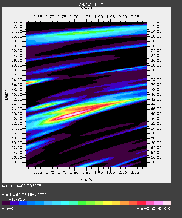
48.25 km |
| Estimated Crust Vp/Vs: |
1.78 |
| Assumed Crust Vp: |
6.61 km/s |
| Estimated Crust Vs: |
3.708 km/s |
| Estimated Crust Poisson's Ratio: |
0.27 |
|
| Radial Match: |
83.786835 % |
| Radial Bump: |
237 |
| Transverse Match: |
71.88394 % |
| Transverse Bump: |
400 |
| SOD ConfigId: |
7422571 |
| Insert Time: |
2019-04-22 12:05:29.715 +0000 |
| GWidth: |
2.5 |
| Max Bumps: |
400 |
| Tol: |
0.001 |
|

Signal To Noise
| Channel | StoN | STA | LTA |
| CN:A61: :HHZ:20160429T01:41:37.890007Z | 4.4263687 | 1.2164511E-6 | 2.748192E-7 |
| CN:A61: :HHN:20160429T01:41:37.890007Z | 2.6903179 | 5.187463E-7 | 1.928197E-7 |
| CN:A61: :HHE:20160429T01:41:37.890007Z | 1.8032603 | 5.3445206E-7 | 2.96381E-7 |
| Arrivals |
| Ps | 6.1 SECOND |
| PpPs | 19 SECOND |
| PsPs/PpSs | 25 SECOND |


