You are here: Home > Network List > LD - Lamont-Doherty Cooperative Seismographic Network Stations List
> Station MSNJ Montclair State University, NJ > Earthquake Result Viewer
MSNJ Montclair State University, NJ - Earthquake Result Viewer
| Earthquake location: |
Northern East Pacific Rise |
| Earthquake latitude/longitude: |
10.3/-103.8 |
| Earthquake time(UTC): |
2016/04/29 (120) 01:33:38 GMT |
| Earthquake Depth: |
10 km |
| Earthquake Magnitude: |
6.8 MWP, 6.9 MI |
| Earthquake Catalog/Contributor: |
NEIC PDE/NEIC COMCAT |
|
| Network: |
LD Lamont-Doherty Cooperative Seismographic Network |
| Station: |
MSNJ Montclair State University, NJ |
| Lat/Lon: |
40.88 N/74.18 W |
| Elevation: |
132 m |
|
| Distance: |
40.2 deg |
| Az: |
35.478 deg |
| Baz: |
228.887 deg |
| Ray Param: |
0.07455311 |
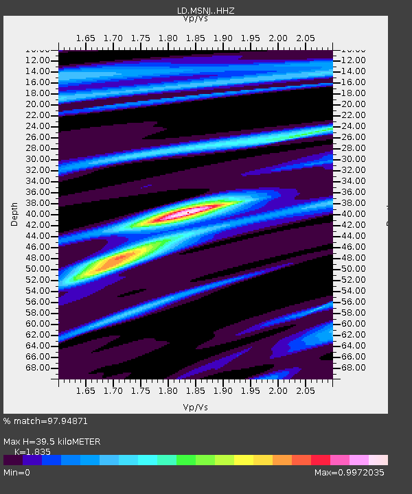
| Estimated Moho Depth: |
39.5 km |
| Estimated Crust Vp/Vs: |
1.84 |
| Assumed Crust Vp: |
6.283 km/s |
| Estimated Crust Vs: |
3.424 km/s |
| Estimated Crust Poisson's Ratio: |
0.29 |
|
| Radial Match: |
97.94871 % |
| Radial Bump: |
192 |
| Transverse Match: |
78.09995 % |
| Transverse Bump: |
400 |
| SOD ConfigId: |
7422571 |
| Insert Time: |
2019-04-22 12:07:14.121 +0000 |
| GWidth: |
2.5 |
| Max Bumps: |
400 |
| Tol: |
0.001 |
|

Signal To Noise
| Channel | StoN | STA | LTA |
| LD:MSNJ: :HHZ:20160429T01:40:43.885002Z | 8.259243 | 1.6758243E-6 | 2.029029E-7 |
| LD:MSNJ: :HHN:20160429T01:40:43.885002Z | 3.195963 | 5.6929525E-7 | 1.781295E-7 |
| LD:MSNJ: :HHE:20160429T01:40:43.885002Z | 5.7082863 | 9.157792E-7 | 1.6042979E-7 |
| Arrivals |
| Ps | 5.6 SECOND |
| PpPs | 17 SECOND |
| PsPs/PpSs | 22 SECOND |


