You are here: Home > Network List > LD - Lamont-Doherty Cooperative Seismographic Network Stations List
> Station MVL Millersville University, PA > Earthquake Result Viewer
MVL Millersville University, PA - Earthquake Result Viewer

| Earthquake location: |
Northern East Pacific Rise |
| Earthquake latitude/longitude: |
10.3/-103.8 |
| Earthquake time(UTC): |
2016/04/29 (120) 01:33:38 GMT |
| Earthquake Depth: |
10 km |
| Earthquake Magnitude: |
6.8 MWP, 6.9 MI |
| Earthquake Catalog/Contributor: |
NEIC PDE/NEIC COMCAT |
|
| Network: |
LD Lamont-Doherty Cooperative Seismographic Network |
| Station: |
MVL Millersville University, PA |
| Lat/Lon: |
40.00 N/76.35 W |
| Elevation: |
91 m |
|
| Distance: |
38.3 deg |
| Az: |
34.76 deg |
| Baz: |
226.929 deg |
| Ray Param: |
0.07562075 |
| Estimated Moho Depth: |
29.0 km |
| Estimated Crust Vp/Vs: |
2.00 |
| Assumed Crust Vp: |
6.419 km/s |
| Estimated Crust Vs: |
3.214 km/s |
| Estimated Crust Poisson's Ratio: |
0.33 |
|
| Radial Match: |
98.30925 % |
| Radial Bump: |
150 |
| Transverse Match: |
94.407745 % |
| Transverse Bump: |
330 |
| SOD ConfigId: |
7422571 |
| Insert Time: |
2019-04-22 12:07:15.047 +0000 |
| GWidth: |
2.5 |
| Max Bumps: |
400 |
| Tol: |
0.001 |
|
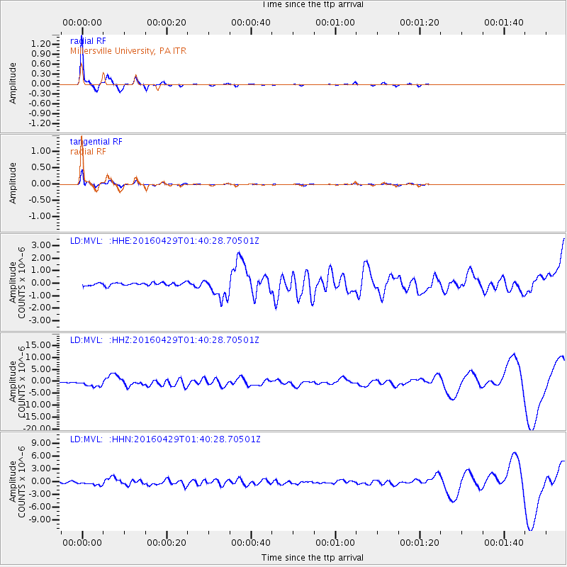
Signal To Noise
| Channel | StoN | STA | LTA |
| LD:MVL: :HHZ:20160429T01:40:28.70501Z | 7.6897883 | 1.2723243E-6 | 1.6545634E-7 |
| LD:MVL: :HHN:20160429T01:40:28.70501Z | 3.3133497 | 4.7045248E-7 | 1.4198696E-7 |
| LD:MVL: :HHE:20160429T01:40:28.70501Z | 7.7942038 | 8.869156E-7 | 1.13791685E-7 |
| Arrivals |
| Ps | 4.8 SECOND |
| PpPs | 13 SECOND |
| PsPs/PpSs | 18 SECOND |


