You are here: Home > Network List > US - United States National Seismic Network Stations List
> Station LRAL Lakeview Retreat, Alabama, USA > Earthquake Result Viewer
LRAL Lakeview Retreat, Alabama, USA - Earthquake Result Viewer
| Earthquake location: |
South Pacific Ocean |
| Earthquake latitude/longitude: |
-20.3/-126.9 |
| Earthquake time(UTC): |
2004/07/11 (193) 23:46:12 GMT |
| Earthquake Depth: |
12 km |
| Earthquake Magnitude: |
6.1 MB, 5.9 MS, 6.1 MW, 6.1 MW |
| Earthquake Catalog/Contributor: |
WHDF/NEIC |
|
| Network: |
US United States National Seismic Network |
| Station: |
LRAL Lakeview Retreat, Alabama, USA |
| Lat/Lon: |
33.03 N/87.00 W |
| Elevation: |
130 m |
|
| Distance: |
65.3 deg |
| Az: |
36.408 deg |
| Baz: |
221.562 deg |
| Ray Param: |
0.058367796 |
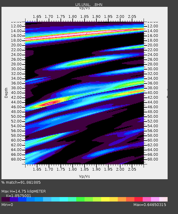
| Estimated Moho Depth: |
14.75 km |
| Estimated Crust Vp/Vs: |
1.86 |
| Assumed Crust Vp: |
6.565 km/s |
| Estimated Crust Vs: |
3.534 km/s |
| Estimated Crust Poisson's Ratio: |
0.30 |
|
| Radial Match: |
91.861885 % |
| Radial Bump: |
400 |
| Transverse Match: |
84.87811 % |
| Transverse Bump: |
400 |
| SOD ConfigId: |
110177 |
| Insert Time: |
2010-03-05 02:31:43.948 +0000 |
| GWidth: |
2.5 |
| Max Bumps: |
400 |
| Tol: |
0.001 |
|

Signal To Noise
| Channel | StoN | STA | LTA |
| US:LRAL: :BHN:20040711T23:56:22.989016Z | 3.7960262 | 3.4865872E-7 | 9.184834E-8 |
| US:LRAL: :BHE:20040711T23:56:22.989016Z | 7.5515947 | 5.215723E-7 | 6.906784E-8 |
| US:LRAL: :BHZ:20040711T23:56:22.989016Z | 12.733129 | 1.8860849E-6 | 1.4812423E-7 |
| Arrivals |
| Ps | 2.0 SECOND |
| PpPs | 6.2 SECOND |
| PsPs/PpSs | 8.2 SECOND |


