You are here: Home > Network List > N4 - Central and EAstern US Network Stations List
> Station L48A N Adams, MI, USA > Earthquake Result Viewer
L48A N Adams, MI, USA - Earthquake Result Viewer
| Earthquake location: |
Northern East Pacific Rise |
| Earthquake latitude/longitude: |
10.3/-103.8 |
| Earthquake time(UTC): |
2016/04/29 (120) 01:33:38 GMT |
| Earthquake Depth: |
10 km |
| Earthquake Magnitude: |
6.8 MWP, 6.9 MI |
| Earthquake Catalog/Contributor: |
NEIC PDE/NEIC COMCAT |
|
| Network: |
N4 Central and EAstern US Network |
| Station: |
L48A N Adams, MI, USA |
| Lat/Lon: |
41.94 N/84.43 W |
| Elevation: |
369 m |
|
| Distance: |
35.8 deg |
| Az: |
24.941 deg |
| Baz: |
213.803 deg |
| Ray Param: |
0.07700492 |
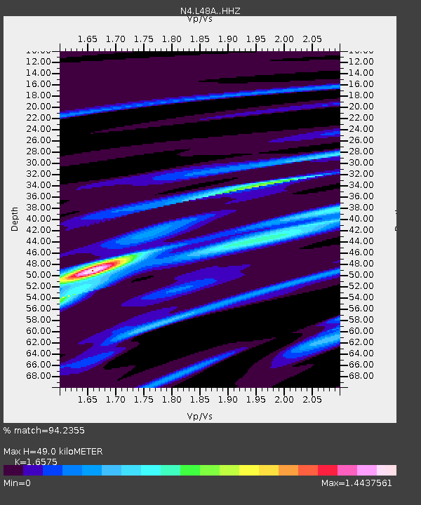
| Estimated Moho Depth: |
49.0 km |
| Estimated Crust Vp/Vs: |
1.66 |
| Assumed Crust Vp: |
6.498 km/s |
| Estimated Crust Vs: |
3.92 km/s |
| Estimated Crust Poisson's Ratio: |
0.21 |
|
| Radial Match: |
94.2355 % |
| Radial Bump: |
231 |
| Transverse Match: |
70.687706 % |
| Transverse Bump: |
400 |
| SOD ConfigId: |
7422571 |
| Insert Time: |
2019-04-22 12:08:03.994 +0000 |
| GWidth: |
2.5 |
| Max Bumps: |
400 |
| Tol: |
0.001 |
|

Signal To Noise
| Channel | StoN | STA | LTA |
| N4:L48A: :HHZ:20160429T01:40:07.55999Z | 20.109663 | 3.1452887E-6 | 1.5640684E-7 |
| N4:L48A: :HHN:20160429T01:40:07.55999Z | 14.248001 | 1.8942815E-6 | 1.3295069E-7 |
| N4:L48A: :HHE:20160429T01:40:07.55999Z | 8.27525 | 1.0961169E-6 | 1.3245725E-7 |
| Arrivals |
| Ps | 5.4 SECOND |
| PpPs | 18 SECOND |
| PsPs/PpSs | 24 SECOND |


