You are here: Home > Network List > N4 - Central and EAstern US Network Stations List
> Station P51A Williamsport, OH, USA > Earthquake Result Viewer
P51A Williamsport, OH, USA - Earthquake Result Viewer
| Earthquake location: |
Northern East Pacific Rise |
| Earthquake latitude/longitude: |
10.3/-103.8 |
| Earthquake time(UTC): |
2016/04/29 (120) 01:33:38 GMT |
| Earthquake Depth: |
10 km |
| Earthquake Magnitude: |
6.8 MWP, 6.9 MI |
| Earthquake Catalog/Contributor: |
NEIC PDE/NEIC COMCAT |
|
| Network: |
N4 Central and EAstern US Network |
| Station: |
P51A Williamsport, OH, USA |
| Lat/Lon: |
39.48 N/83.06 W |
| Elevation: |
211 m |
|
| Distance: |
34.5 deg |
| Az: |
28.914 deg |
| Baz: |
217.944 deg |
| Ray Param: |
0.07772995 |
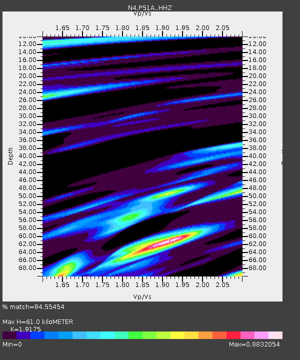
| Estimated Moho Depth: |
61.0 km |
| Estimated Crust Vp/Vs: |
1.92 |
| Assumed Crust Vp: |
6.232 km/s |
| Estimated Crust Vs: |
3.25 km/s |
| Estimated Crust Poisson's Ratio: |
0.31 |
|
| Radial Match: |
94.55454 % |
| Radial Bump: |
400 |
| Transverse Match: |
70.81697 % |
| Transverse Bump: |
400 |
| SOD ConfigId: |
7422571 |
| Insert Time: |
2019-04-22 12:08:24.501 +0000 |
| GWidth: |
2.5 |
| Max Bumps: |
400 |
| Tol: |
0.001 |
|

Signal To Noise
| Channel | StoN | STA | LTA |
| N4:P51A: :HHZ:20160429T01:39:55.670006Z | 17.91551 | 2.6082778E-6 | 1.455877E-7 |
| N4:P51A: :HHN:20160429T01:39:55.670006Z | 8.432696 | 1.3168666E-6 | 1.5616199E-7 |
| N4:P51A: :HHE:20160429T01:39:55.670006Z | 7.762675 | 1.116268E-6 | 1.437994E-7 |
| Arrivals |
| Ps | 9.6 SECOND |
| PpPs | 27 SECOND |
| PsPs/PpSs | 36 SECOND |


