You are here: Home > Network List > N4 - Central and EAstern US Network Stations List
> Station V53A Sandy Mush, NC, USA > Earthquake Result Viewer
V53A Sandy Mush, NC, USA - Earthquake Result Viewer
| Earthquake location: |
Northern East Pacific Rise |
| Earthquake latitude/longitude: |
10.3/-103.8 |
| Earthquake time(UTC): |
2016/04/29 (120) 01:33:38 GMT |
| Earthquake Depth: |
10 km |
| Earthquake Magnitude: |
6.8 MWP, 6.9 MI |
| Earthquake Catalog/Contributor: |
NEIC PDE/NEIC COMCAT |
|
| Network: |
N4 Central and EAstern US Network |
| Station: |
V53A Sandy Mush, NC, USA |
| Lat/Lon: |
35.67 N/82.81 W |
| Elevation: |
681 m |
|
| Distance: |
31.7 deg |
| Az: |
33.676 deg |
| Baz: |
222.087 deg |
| Ray Param: |
0.07897818 |
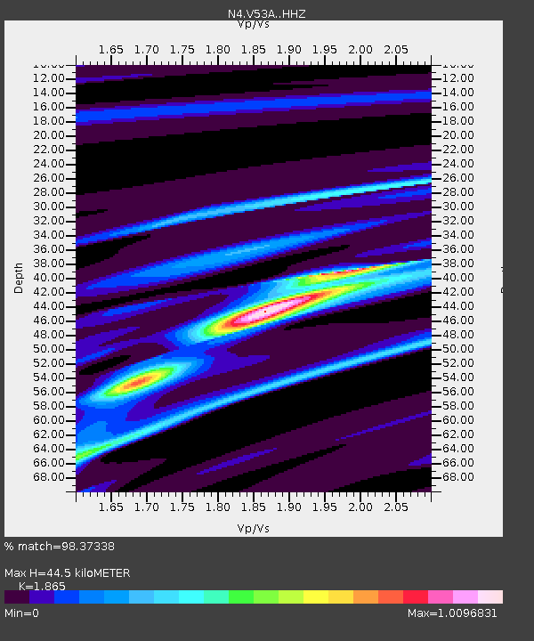
| Estimated Moho Depth: |
44.5 km |
| Estimated Crust Vp/Vs: |
1.87 |
| Assumed Crust Vp: |
6.35 km/s |
| Estimated Crust Vs: |
3.405 km/s |
| Estimated Crust Poisson's Ratio: |
0.30 |
|
| Radial Match: |
98.37338 % |
| Radial Bump: |
146 |
| Transverse Match: |
85.01573 % |
| Transverse Bump: |
400 |
| SOD ConfigId: |
7422571 |
| Insert Time: |
2019-04-22 12:08:47.542 +0000 |
| GWidth: |
2.5 |
| Max Bumps: |
400 |
| Tol: |
0.001 |
|

Signal To Noise
| Channel | StoN | STA | LTA |
| N4:V53A: :HHZ:20160429T01:39:31.360009Z | 18.313755 | 2.462085E-6 | 1.344391E-7 |
| N4:V53A: :HHN:20160429T01:39:31.360009Z | 10.230233 | 1.1249695E-6 | 1.09965185E-7 |
| N4:V53A: :HHE:20160429T01:39:31.360009Z | 9.834449 | 1.1450712E-6 | 1.1643471E-7 |
| Arrivals |
| Ps | 6.5 SECOND |
| PpPs | 19 SECOND |
| PsPs/PpSs | 25 SECOND |


