You are here: Home > Network List > N4 - Central and EAstern US Network Stations List
> Station V58A WIndy Hill, Pittsboro, NC, USA > Earthquake Result Viewer
V58A WIndy Hill, Pittsboro, NC, USA - Earthquake Result Viewer
| Earthquake location: |
Northern East Pacific Rise |
| Earthquake latitude/longitude: |
10.3/-103.8 |
| Earthquake time(UTC): |
2016/04/29 (120) 01:33:38 GMT |
| Earthquake Depth: |
10 km |
| Earthquake Magnitude: |
6.8 MWP, 6.9 MI |
| Earthquake Catalog/Contributor: |
NEIC PDE/NEIC COMCAT |
|
| Network: |
N4 Central and EAstern US Network |
| Station: |
V58A WIndy Hill, Pittsboro, NC, USA |
| Lat/Lon: |
35.79 N/79.11 W |
| Elevation: |
127 m |
|
| Distance: |
33.9 deg |
| Az: |
37.46 deg |
| Baz: |
227.42 deg |
| Ray Param: |
0.07800514 |
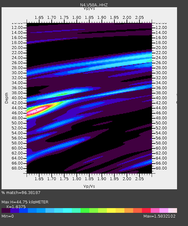
| Estimated Moho Depth: |
44.75 km |
| Estimated Crust Vp/Vs: |
1.64 |
| Assumed Crust Vp: |
6.565 km/s |
| Estimated Crust Vs: |
4.009 km/s |
| Estimated Crust Poisson's Ratio: |
0.20 |
|
| Radial Match: |
96.38187 % |
| Radial Bump: |
186 |
| Transverse Match: |
88.06255 % |
| Transverse Bump: |
400 |
| SOD ConfigId: |
7422571 |
| Insert Time: |
2019-04-22 12:08:50.025 +0000 |
| GWidth: |
2.5 |
| Max Bumps: |
400 |
| Tol: |
0.001 |
|

Signal To Noise
| Channel | StoN | STA | LTA |
| N4:V58A: :HHZ:20160429T01:39:50.610009Z | 19.899803 | 2.4773096E-6 | 1.2448916E-7 |
| N4:V58A: :HHN:20160429T01:39:50.610009Z | 7.5489593 | 1.0829963E-6 | 1.4346298E-7 |
| N4:V58A: :HHE:20160429T01:39:50.610009Z | 17.383821 | 1.2610212E-6 | 7.253993E-8 |
| Arrivals |
| Ps | 4.7 SECOND |
| PpPs | 16 SECOND |
| PsPs/PpSs | 21 SECOND |


