You are here: Home > Network List > PE - Penn State Network Stations List
> Station PARS Ryerson Station State Park, Wind Ridge, PA > Earthquake Result Viewer
PARS Ryerson Station State Park, Wind Ridge, PA - Earthquake Result Viewer
| Earthquake location: |
Northern East Pacific Rise |
| Earthquake latitude/longitude: |
10.3/-103.8 |
| Earthquake time(UTC): |
2016/04/29 (120) 01:33:38 GMT |
| Earthquake Depth: |
10 km |
| Earthquake Magnitude: |
6.8 MWP, 6.9 MI |
| Earthquake Catalog/Contributor: |
NEIC PDE/NEIC COMCAT |
|
| Network: |
PE Penn State Network |
| Station: |
PARS Ryerson Station State Park, Wind Ridge, PA |
| Lat/Lon: |
39.89 N/80.45 W |
| Elevation: |
305 m |
|
| Distance: |
36.1 deg |
| Az: |
31.156 deg |
| Baz: |
221.439 deg |
| Ray Param: |
0.07688631 |
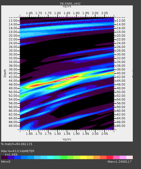
| Estimated Moho Depth: |
43.0 km |
| Estimated Crust Vp/Vs: |
1.85 |
| Assumed Crust Vp: |
6.207 km/s |
| Estimated Crust Vs: |
3.364 km/s |
| Estimated Crust Poisson's Ratio: |
0.29 |
|
| Radial Match: |
94.861115 % |
| Radial Bump: |
340 |
| Transverse Match: |
90.63574 % |
| Transverse Bump: |
400 |
| SOD ConfigId: |
7422571 |
| Insert Time: |
2019-04-22 12:09:50.041 +0000 |
| GWidth: |
2.5 |
| Max Bumps: |
400 |
| Tol: |
0.001 |
|

Signal To Noise
| Channel | StoN | STA | LTA |
| PE:PARS: :HHZ:20160429T01:40:09.409996Z | 12.216754 | 2.220132E-6 | 1.8172847E-7 |
| PE:PARS: :HHN:20160429T01:40:09.409996Z | 8.583289 | 1.3146421E-6 | 1.5316297E-7 |
| PE:PARS: :HHE:20160429T01:40:09.409996Z | 2.694956 | 5.5408015E-7 | 2.0559897E-7 |
| Arrivals |
| Ps | 6.3 SECOND |
| PpPs | 18 SECOND |
| PsPs/PpSs | 25 SECOND |


