You are here: Home > Network List > PO - Portable Observatories for Lithospheric Analysis and Research Investigating Seis Stations List
> Station LATQ La Tuque, Quebec, QC > Earthquake Result Viewer
LATQ La Tuque, Quebec, QC - Earthquake Result Viewer
| Earthquake location: |
Northern East Pacific Rise |
| Earthquake latitude/longitude: |
10.3/-103.8 |
| Earthquake time(UTC): |
2016/04/29 (120) 01:33:38 GMT |
| Earthquake Depth: |
10 km |
| Earthquake Magnitude: |
6.8 MWP, 6.9 MI |
| Earthquake Catalog/Contributor: |
NEIC PDE/NEIC COMCAT |
|
| Network: |
PO Portable Observatories for Lithospheric Analysis and Research Investigating Seis |
| Station: |
LATQ La Tuque, Quebec, QC |
| Lat/Lon: |
47.38 N/72.78 W |
| Elevation: |
163 m |
|
| Distance: |
45.3 deg |
| Az: |
29.468 deg |
| Baz: |
225.439 deg |
| Ray Param: |
0.07135591 |
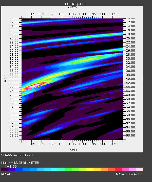
| Estimated Moho Depth: |
43.25 km |
| Estimated Crust Vp/Vs: |
1.66 |
| Assumed Crust Vp: |
6.61 km/s |
| Estimated Crust Vs: |
3.982 km/s |
| Estimated Crust Poisson's Ratio: |
0.22 |
|
| Radial Match: |
89.51223 % |
| Radial Bump: |
289 |
| Transverse Match: |
64.642654 % |
| Transverse Bump: |
400 |
| SOD ConfigId: |
7422571 |
| Insert Time: |
2019-04-22 12:10:04.348 +0000 |
| GWidth: |
2.5 |
| Max Bumps: |
400 |
| Tol: |
0.001 |
|

Signal To Noise
| Channel | StoN | STA | LTA |
| PO:LATQ: :HHZ:20160429T01:41:25.749993Z | 5.9155283 | 1.7924841E-6 | 3.0301337E-7 |
| PO:LATQ: :HHN:20160429T01:41:25.749993Z | 4.0182896 | 8.0453236E-7 | 2.0021763E-7 |
| PO:LATQ: :HHE:20160429T01:41:25.749993Z | 4.017018 | 8.309338E-7 | 2.0685341E-7 |
| Arrivals |
| Ps | 4.6 SECOND |
| PpPs | 16 SECOND |
| PsPs/PpSs | 21 SECOND |


