You are here: Home > Network List > PR - Puerto Rico Seismic Network (PRSN) & Puerto Rico Strong Motion Program (PRSMP) Stations List
> Station CRPR Cabo Rojo, Puerto Rico(T3K97) > Earthquake Result Viewer
CRPR Cabo Rojo, Puerto Rico(T3K97) - Earthquake Result Viewer
| Earthquake location: |
Northern East Pacific Rise |
| Earthquake latitude/longitude: |
10.3/-103.8 |
| Earthquake time(UTC): |
2016/04/29 (120) 01:33:38 GMT |
| Earthquake Depth: |
10 km |
| Earthquake Magnitude: |
6.8 MWP, 6.9 MI |
| Earthquake Catalog/Contributor: |
NEIC PDE/NEIC COMCAT |
|
| Network: |
PR Puerto Rico Seismic Network (PRSN) & Puerto Rico Strong Motion Program (PRSMP) |
| Station: |
CRPR Cabo Rojo, Puerto Rico(T3K97) |
| Lat/Lon: |
18.01 N/67.11 W |
| Elevation: |
65 m |
|
| Distance: |
36.3 deg |
| Az: |
73.579 deg |
| Baz: |
262.787 deg |
| Ray Param: |
0.076747224 |
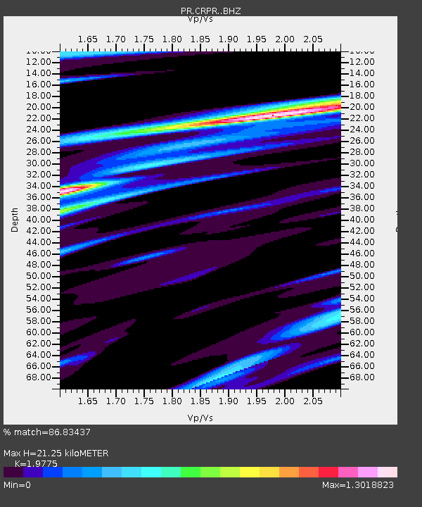
| Estimated Moho Depth: |
21.25 km |
| Estimated Crust Vp/Vs: |
1.98 |
| Assumed Crust Vp: |
5.14 km/s |
| Estimated Crust Vs: |
2.599 km/s |
| Estimated Crust Poisson's Ratio: |
0.33 |
|
| Radial Match: |
86.83437 % |
| Radial Bump: |
400 |
| Transverse Match: |
71.85257 % |
| Transverse Bump: |
400 |
| SOD ConfigId: |
7422571 |
| Insert Time: |
2019-04-22 12:10:13.979 +0000 |
| GWidth: |
2.5 |
| Max Bumps: |
400 |
| Tol: |
0.001 |
|

Signal To Noise
| Channel | StoN | STA | LTA |
| PR:CRPR: :BHZ:20160429T01:40:11.624993Z | 5.19203 | 1.2699644E-6 | 2.4459882E-7 |
| PR:CRPR: :BHN:20160429T01:40:11.624993Z | 1.6540502 | 5.24997E-7 | 3.174009E-7 |
| PR:CRPR: :BHE:20160429T01:40:11.624993Z | 3.255997 | 6.3452245E-7 | 1.9487807E-7 |
| Arrivals |
| Ps | 4.2 SECOND |
| PpPs | 12 SECOND |
| PsPs/PpSs | 16 SECOND |


