You are here: Home > Network List > TA - USArray Transportable Network (new EarthScope stations) Stations List
> Station G03D McMinnville, OR, USA > Earthquake Result Viewer
G03D McMinnville, OR, USA - Earthquake Result Viewer
| Earthquake location: |
Northern East Pacific Rise |
| Earthquake latitude/longitude: |
10.3/-103.8 |
| Earthquake time(UTC): |
2016/04/29 (120) 01:33:38 GMT |
| Earthquake Depth: |
10 km |
| Earthquake Magnitude: |
6.8 MWP, 6.9 MI |
| Earthquake Catalog/Contributor: |
NEIC PDE/NEIC COMCAT |
|
| Network: |
TA USArray Transportable Network (new EarthScope stations) |
| Station: |
G03D McMinnville, OR, USA |
| Lat/Lon: |
45.21 N/123.26 W |
| Elevation: |
222 m |
|
| Distance: |
38.7 deg |
| Az: |
337.804 deg |
| Baz: |
148.264 deg |
| Ray Param: |
0.07543452 |
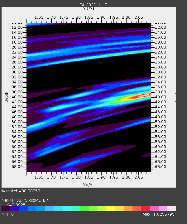
| Estimated Moho Depth: |
38.75 km |
| Estimated Crust Vp/Vs: |
2.09 |
| Assumed Crust Vp: |
6.566 km/s |
| Estimated Crust Vs: |
3.138 km/s |
| Estimated Crust Poisson's Ratio: |
0.35 |
|
| Radial Match: |
80.30259 % |
| Radial Bump: |
351 |
| Transverse Match: |
65.45823 % |
| Transverse Bump: |
400 |
| SOD ConfigId: |
7422571 |
| Insert Time: |
2019-04-22 12:10:43.876 +0000 |
| GWidth: |
2.5 |
| Max Bumps: |
400 |
| Tol: |
0.001 |
|
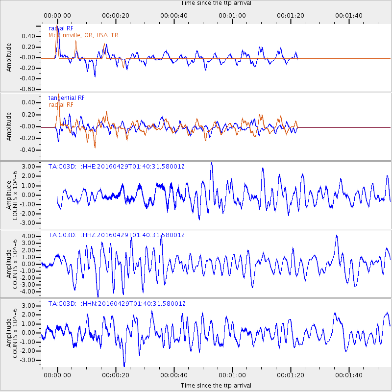
Signal To Noise
| Channel | StoN | STA | LTA |
| TA:G03D: :HHZ:20160429T01:40:31.58001Z | 2.0246625 | 9.2735866E-7 | 4.5803125E-7 |
| TA:G03D: :HHN:20160429T01:40:31.58001Z | 1.1010549 | 8.095065E-7 | 7.3520994E-7 |
| TA:G03D: :HHE:20160429T01:40:31.58001Z | 1.5873463 | 8.180404E-7 | 5.1535096E-7 |
| Arrivals |
| Ps | 6.9 SECOND |
| PpPs | 17 SECOND |
| PsPs/PpSs | 24 SECOND |


