You are here: Home > Network List > TA - USArray Transportable Network (new EarthScope stations) Stations List
> Station K04D Chiloquin, OR, USA > Earthquake Result Viewer
K04D Chiloquin, OR, USA - Earthquake Result Viewer
| Earthquake location: |
Northern East Pacific Rise |
| Earthquake latitude/longitude: |
10.3/-103.8 |
| Earthquake time(UTC): |
2016/04/29 (120) 01:33:38 GMT |
| Earthquake Depth: |
10 km |
| Earthquake Magnitude: |
6.8 MWP, 6.9 MI |
| Earthquake Catalog/Contributor: |
NEIC PDE/NEIC COMCAT |
|
| Network: |
TA USArray Transportable Network (new EarthScope stations) |
| Station: |
K04D Chiloquin, OR, USA |
| Lat/Lon: |
42.62 N/121.75 W |
| Elevation: |
1315 m |
|
| Distance: |
35.9 deg |
| Az: |
337.111 deg |
| Baz: |
148.756 deg |
| Ray Param: |
0.07698297 |
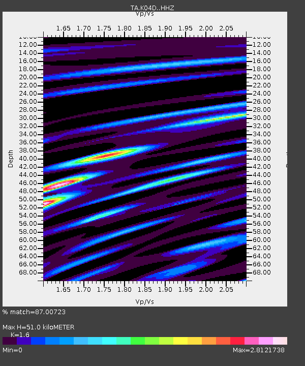
| Estimated Moho Depth: |
51.0 km |
| Estimated Crust Vp/Vs: |
1.60 |
| Assumed Crust Vp: |
6.597 km/s |
| Estimated Crust Vs: |
4.123 km/s |
| Estimated Crust Poisson's Ratio: |
0.18 |
|
| Radial Match: |
87.00723 % |
| Radial Bump: |
400 |
| Transverse Match: |
59.556194 % |
| Transverse Bump: |
400 |
| SOD ConfigId: |
7422571 |
| Insert Time: |
2019-04-22 12:11:01.321 +0000 |
| GWidth: |
2.5 |
| Max Bumps: |
400 |
| Tol: |
0.001 |
|
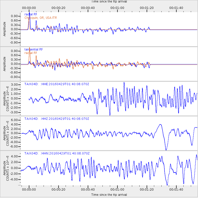
Signal To Noise
| Channel | StoN | STA | LTA |
| TA:K04D: :HHZ:20160429T01:40:08.070Z | 6.1538396 | 9.52682E-7 | 1.5481099E-7 |
| TA:K04D: :HHN:20160429T01:40:08.070Z | 1.0542027 | 4.5957304E-7 | 4.3594372E-7 |
| TA:K04D: :HHE:20160429T01:40:08.070Z | 0.5760452 | 2.435954E-7 | 4.228755E-7 |
| Arrivals |
| Ps | 5.1 SECOND |
| PpPs | 18 SECOND |
| PsPs/PpSs | 23 SECOND |


