You are here: Home > Network List > TA - USArray Transportable Network (new EarthScope stations) Stations List
> Station O20A White River City, CO, USA > Earthquake Result Viewer
O20A White River City, CO, USA - Earthquake Result Viewer
| Earthquake location: |
Northern East Pacific Rise |
| Earthquake latitude/longitude: |
10.3/-103.8 |
| Earthquake time(UTC): |
2016/04/29 (120) 01:33:38 GMT |
| Earthquake Depth: |
10 km |
| Earthquake Magnitude: |
6.8 MWP, 6.9 MI |
| Earthquake Catalog/Contributor: |
NEIC PDE/NEIC COMCAT |
|
| Network: |
TA USArray Transportable Network (new EarthScope stations) |
| Station: |
O20A White River City, CO, USA |
| Lat/Lon: |
40.13 N/108.24 W |
| Elevation: |
1915 m |
|
| Distance: |
30.0 deg |
| Az: |
353.127 deg |
| Baz: |
171.162 deg |
| Ray Param: |
0.079440236 |
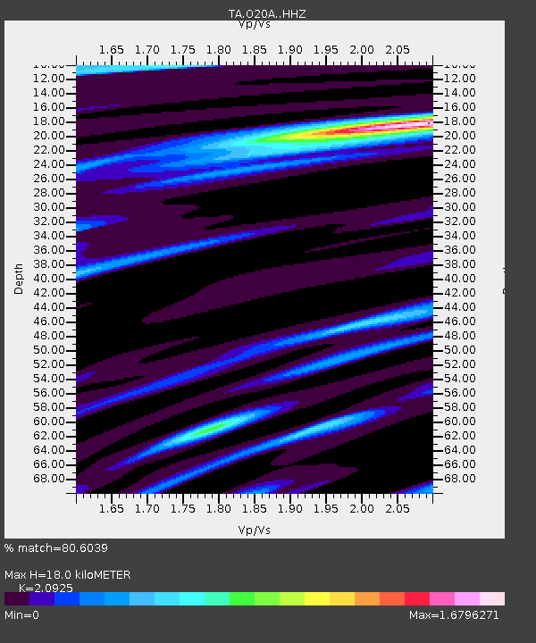
| Estimated Moho Depth: |
18.0 km |
| Estimated Crust Vp/Vs: |
2.09 |
| Assumed Crust Vp: |
6.207 km/s |
| Estimated Crust Vs: |
2.966 km/s |
| Estimated Crust Poisson's Ratio: |
0.35 |
|
| Radial Match: |
80.6039 % |
| Radial Bump: |
400 |
| Transverse Match: |
65.637314 % |
| Transverse Bump: |
400 |
| SOD ConfigId: |
7422571 |
| Insert Time: |
2019-04-22 12:11:25.169 +0000 |
| GWidth: |
2.5 |
| Max Bumps: |
400 |
| Tol: |
0.001 |
|
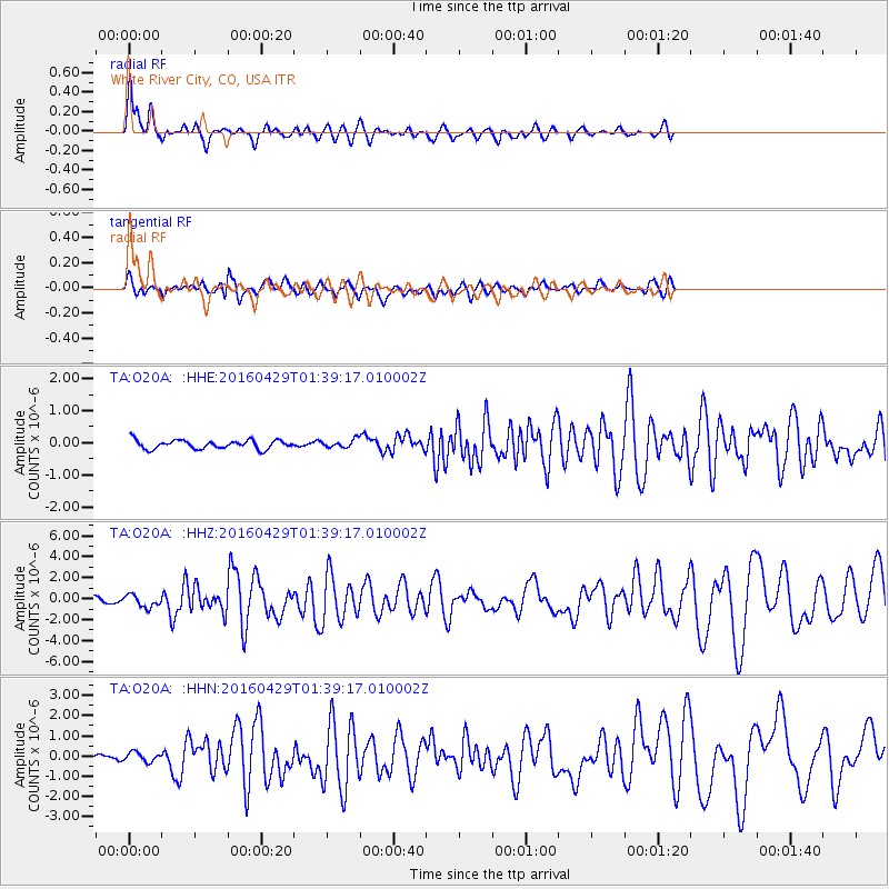
Signal To Noise
| Channel | StoN | STA | LTA |
| TA:O20A: :HHZ:20160429T01:39:17.010002Z | 2.8470879 | 5.8647345E-7 | 2.0599064E-7 |
| TA:O20A: :HHN:20160429T01:39:17.010002Z | 1.0585673 | 2.2970335E-7 | 2.1699455E-7 |
| TA:O20A: :HHE:20160429T01:39:17.010002Z | 0.97654575 | 1.3243287E-7 | 1.3561359E-7 |
| Arrivals |
| Ps | 3.4 SECOND |
| PpPs | 8.4 SECOND |
| PsPs/PpSs | 12 SECOND |


