You are here: Home > Network List > TA - USArray Transportable Network (new EarthScope stations) Stations List
> Station P52A Corning, OH, USA > Earthquake Result Viewer
P52A Corning, OH, USA - Earthquake Result Viewer
| Earthquake location: |
Northern East Pacific Rise |
| Earthquake latitude/longitude: |
10.3/-103.8 |
| Earthquake time(UTC): |
2016/04/29 (120) 01:33:38 GMT |
| Earthquake Depth: |
10 km |
| Earthquake Magnitude: |
6.8 MWP, 6.9 MI |
| Earthquake Catalog/Contributor: |
NEIC PDE/NEIC COMCAT |
|
| Network: |
TA USArray Transportable Network (new EarthScope stations) |
| Station: |
P52A Corning, OH, USA |
| Lat/Lon: |
39.63 N/82.13 W |
| Elevation: |
293 m |
|
| Distance: |
35.0 deg |
| Az: |
29.731 deg |
| Baz: |
219.204 deg |
| Ray Param: |
0.07743744 |
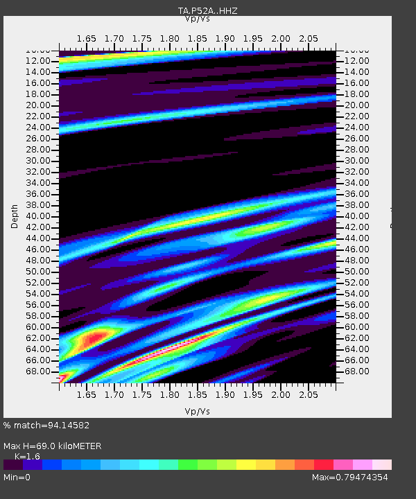
| Estimated Moho Depth: |
69.0 km |
| Estimated Crust Vp/Vs: |
1.60 |
| Assumed Crust Vp: |
6.232 km/s |
| Estimated Crust Vs: |
3.895 km/s |
| Estimated Crust Poisson's Ratio: |
0.18 |
|
| Radial Match: |
94.14582 % |
| Radial Bump: |
302 |
| Transverse Match: |
69.74241 % |
| Transverse Bump: |
400 |
| SOD ConfigId: |
7422571 |
| Insert Time: |
2019-04-22 12:11:28.105 +0000 |
| GWidth: |
2.5 |
| Max Bumps: |
400 |
| Tol: |
0.001 |
|

Signal To Noise
| Channel | StoN | STA | LTA |
| TA:P52A: :HHZ:20160429T01:40:00.550011Z | 16.86269 | 2.2741915E-6 | 1.3486529E-7 |
| TA:P52A: :HHN:20160429T01:40:00.550011Z | 5.932881 | 1.072742E-6 | 1.8081299E-7 |
| TA:P52A: :HHE:20160429T01:40:00.550011Z | 7.4419117 | 9.3985346E-7 | 1.2629194E-7 |
| Arrivals |
| Ps | 7.2 SECOND |
| PpPs | 27 SECOND |
| PsPs/PpSs | 34 SECOND |


