You are here: Home > Network List > TA - USArray Transportable Network (new EarthScope stations) Stations List
> Station SUSD Miller, SD, USA > Earthquake Result Viewer
SUSD Miller, SD, USA - Earthquake Result Viewer
| Earthquake location: |
Northern East Pacific Rise |
| Earthquake latitude/longitude: |
10.3/-103.8 |
| Earthquake time(UTC): |
2016/04/29 (120) 01:33:38 GMT |
| Earthquake Depth: |
10 km |
| Earthquake Magnitude: |
6.8 MWP, 6.9 MI |
| Earthquake Catalog/Contributor: |
NEIC PDE/NEIC COMCAT |
|
| Network: |
TA USArray Transportable Network (new EarthScope stations) |
| Station: |
SUSD Miller, SD, USA |
| Lat/Lon: |
44.44 N/98.96 W |
| Elevation: |
520 m |
|
| Distance: |
34.3 deg |
| Az: |
6.11 deg |
| Baz: |
188.41 deg |
| Ray Param: |
0.07780179 |
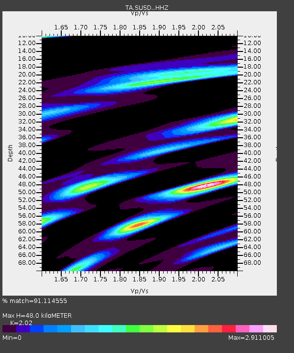
| Estimated Moho Depth: |
48.0 km |
| Estimated Crust Vp/Vs: |
2.02 |
| Assumed Crust Vp: |
6.53 km/s |
| Estimated Crust Vs: |
3.233 km/s |
| Estimated Crust Poisson's Ratio: |
0.34 |
|
| Radial Match: |
91.114555 % |
| Radial Bump: |
400 |
| Transverse Match: |
52.025856 % |
| Transverse Bump: |
400 |
| SOD ConfigId: |
7422571 |
| Insert Time: |
2019-04-22 12:11:34.092 +0000 |
| GWidth: |
2.5 |
| Max Bumps: |
400 |
| Tol: |
0.001 |
|

Signal To Noise
| Channel | StoN | STA | LTA |
| TA:SUSD: :HHZ:20160429T01:39:54.499993Z | 11.006192 | 1.215303E-6 | 1.1041993E-7 |
| TA:SUSD: :HHN:20160429T01:39:54.499993Z | 6.2919116 | 1.0046459E-6 | 1.596726E-7 |
| TA:SUSD: :HHE:20160429T01:39:54.499993Z | 1.5653857 | 2.5223233E-7 | 1.611311E-7 |
| Arrivals |
| Ps | 8.0 SECOND |
| PpPs | 21 SECOND |
| PsPs/PpSs | 29 SECOND |


