You are here: Home > Network List > XD14 - Illuminating the architecture of the greater Mount St. Helens magmatic systems f Stations List
> Station MF09 "Mount St Helens, WA" > Earthquake Result Viewer
MF09 "Mount St Helens, WA" - Earthquake Result Viewer
| Earthquake location: |
Northern East Pacific Rise |
| Earthquake latitude/longitude: |
10.3/-103.8 |
| Earthquake time(UTC): |
2016/04/29 (120) 01:33:38 GMT |
| Earthquake Depth: |
10 km |
| Earthquake Magnitude: |
6.8 MWP, 6.9 MI |
| Earthquake Catalog/Contributor: |
NEIC PDE/NEIC COMCAT |
|
| Network: |
XD Illuminating the architecture of the greater Mount St. Helens magmatic systems f |
| Station: |
MF09 "Mount St Helens, WA" |
| Lat/Lon: |
46.39 N/121.86 W |
| Elevation: |
1216 m |
|
| Distance: |
39.2 deg |
| Az: |
340.1 deg |
| Baz: |
151.053 deg |
| Ray Param: |
0.07513337 |
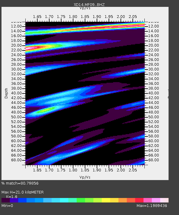
| Estimated Moho Depth: |
21.0 km |
| Estimated Crust Vp/Vs: |
1.60 |
| Assumed Crust Vp: |
6.597 km/s |
| Estimated Crust Vs: |
4.123 km/s |
| Estimated Crust Poisson's Ratio: |
0.18 |
|
| Radial Match: |
80.79856 % |
| Radial Bump: |
306 |
| Transverse Match: |
64.10838 % |
| Transverse Bump: |
400 |
| SOD ConfigId: |
7422571 |
| Insert Time: |
2019-04-22 12:12:44.768 +0000 |
| GWidth: |
2.5 |
| Max Bumps: |
400 |
| Tol: |
0.001 |
|

Signal To Noise
| Channel | StoN | STA | LTA |
| XD:MF09: :BHZ:20160429T01:40:35.939995Z | 4.0759945 | 7.9454145E-7 | 1.9493193E-7 |
| XD:MF09: :BHN:20160429T01:40:35.939995Z | 1.7804419 | 5.839291E-7 | 3.2796862E-7 |
| XD:MF09: :BHE:20160429T01:40:35.939995Z | 1.4906251 | 3.0914157E-7 | 2.0739054E-7 |
| Arrivals |
| Ps | 2.1 SECOND |
| PpPs | 7.6 SECOND |
| PsPs/PpSs | 9.7 SECOND |


