You are here: Home > Network List > XD14 - Illuminating the architecture of the greater Mount St. Helens magmatic systems f Stations List
> Station MO07 "Mount St Helens, WA" > Earthquake Result Viewer
MO07 "Mount St Helens, WA" - Earthquake Result Viewer
| Earthquake location: |
Northern East Pacific Rise |
| Earthquake latitude/longitude: |
10.3/-103.8 |
| Earthquake time(UTC): |
2016/04/29 (120) 01:33:38 GMT |
| Earthquake Depth: |
10 km |
| Earthquake Magnitude: |
6.8 MWP, 6.9 MI |
| Earthquake Catalog/Contributor: |
NEIC PDE/NEIC COMCAT |
|
| Network: |
XD Illuminating the architecture of the greater Mount St. Helens magmatic systems f |
| Station: |
MO07 "Mount St Helens, WA" |
| Lat/Lon: |
45.89 N/122.08 W |
| Elevation: |
1248 m |
|
| Distance: |
38.8 deg |
| Az: |
339.493 deg |
| Baz: |
150.42 deg |
| Ray Param: |
0.07534393 |
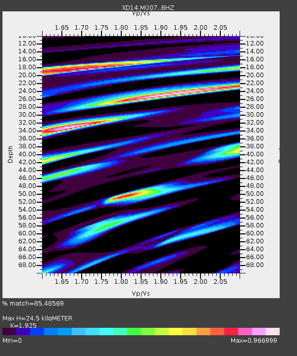
| Estimated Moho Depth: |
24.5 km |
| Estimated Crust Vp/Vs: |
1.92 |
| Assumed Crust Vp: |
6.566 km/s |
| Estimated Crust Vs: |
3.411 km/s |
| Estimated Crust Poisson's Ratio: |
0.32 |
|
| Radial Match: |
85.48569 % |
| Radial Bump: |
366 |
| Transverse Match: |
64.641106 % |
| Transverse Bump: |
400 |
| SOD ConfigId: |
7422571 |
| Insert Time: |
2019-04-22 12:13:15.270 +0000 |
| GWidth: |
2.5 |
| Max Bumps: |
400 |
| Tol: |
0.001 |
|

Signal To Noise
| Channel | StoN | STA | LTA |
| XD:MO07: :BHZ:20160429T01:40:32.895012Z | 2.6835349 | 7.0366485E-7 | 2.6221565E-7 |
| XD:MO07: :BHN:20160429T01:40:32.895012Z | 2.4887764 | 5.241702E-7 | 2.1061362E-7 |
| XD:MO07: :BHE:20160429T01:40:32.895012Z | 1.8529651 | 4.0675664E-7 | 2.1951662E-7 |
| Arrivals |
| Ps | 3.7 SECOND |
| PpPs | 10 SECOND |
| PsPs/PpSs | 14 SECOND |


