You are here: Home > Network List > CI - Caltech Regional Seismic Network Stations List
> Station NEE2 Needles Airport > Earthquake Result Viewer
NEE2 Needles Airport - Earthquake Result Viewer
| Earthquake location: |
East Of Kuril Islands |
| Earthquake latitude/longitude: |
46.7/155.5 |
| Earthquake time(UTC): |
2006/11/28 (332) 08:01:51 GMT |
| Earthquake Depth: |
10 km |
| Earthquake Magnitude: |
5.6 MB, 5.2 MW, 5.2 MW |
| Earthquake Catalog/Contributor: |
WHDF/NEIC |
|
| Network: |
CI Caltech Regional Seismic Network |
| Station: |
NEE2 Needles Airport |
| Lat/Lon: |
34.77 N/114.62 W |
| Elevation: |
271 m |
|
| Distance: |
65.6 deg |
| Az: |
64.696 deg |
| Baz: |
310.888 deg |
| Ray Param: |
0.058170635 |
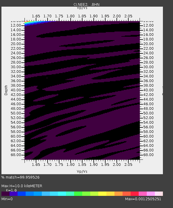
| Estimated Moho Depth: |
10.0 km |
| Estimated Crust Vp/Vs: |
1.60 |
| Assumed Crust Vp: |
6.276 km/s |
| Estimated Crust Vs: |
3.922 km/s |
| Estimated Crust Poisson's Ratio: |
0.18 |
|
| Radial Match: |
99.959526 % |
| Radial Bump: |
5 |
| Transverse Match: |
99.922905 % |
| Transverse Bump: |
26 |
| SOD ConfigId: |
2564 |
| Insert Time: |
2010-02-26 00:20:39.738 +0000 |
| GWidth: |
2.5 |
| Max Bumps: |
400 |
| Tol: |
0.001 |
|
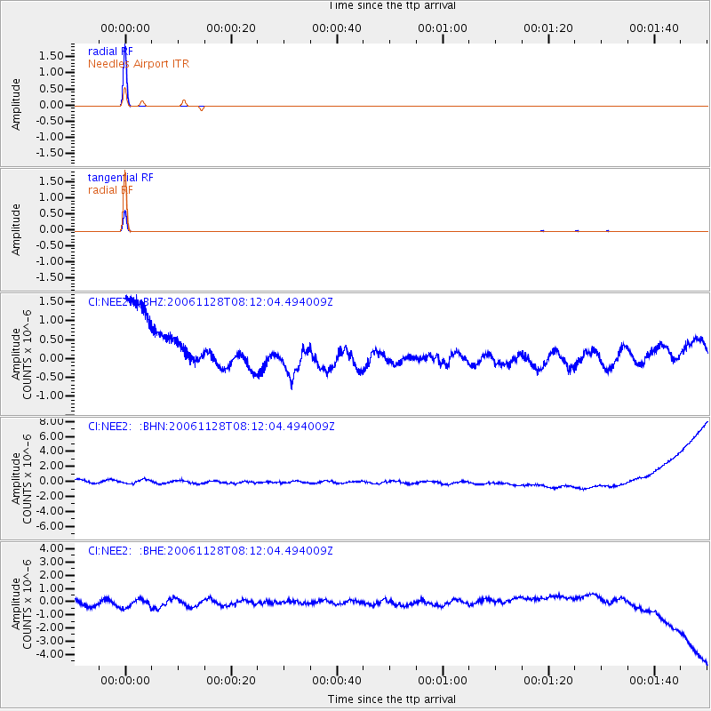
Signal To Noise
| Channel | StoN | STA | LTA |
| CI:NEE2: :BHN:20061128T08:12:04.494009Z | 0.94739366 | 6.065976E-7 | 6.402804E-7 |
| CI:NEE2: :BHE:20061128T08:12:04.494009Z | 1.1307174 | 5.042383E-7 | 4.459455E-7 |
| CI:NEE2: :BHZ:20061128T08:12:04.494009Z | 1.0121715 | 5.974423E-7 | 5.9025797E-7 |
| Arrivals |
| Ps | 1.0 SECOND |
| PpPs | 4.0 SECOND |
| PsPs/PpSs | 5.0 SECOND |


