You are here: Home > Network List > US - United States National Seismic Network Stations List
> Station AMTX Amarillo, Texas, USA > Earthquake Result Viewer
AMTX Amarillo, Texas, USA - Earthquake Result Viewer
*The percent match for this event was below the threshold and hence no stack was calculated.
| Earthquake location: |
Northern Mid-Atlantic Ridge |
| Earthquake latitude/longitude: |
21.1/-45.9 |
| Earthquake time(UTC): |
2015/08/14 (226) 18:03:03 GMT |
| Earthquake Depth: |
13 km |
| Earthquake Magnitude: |
5.5 MB |
| Earthquake Catalog/Contributor: |
NEIC PDE/NEIC COMCAT |
|
| Network: |
US United States National Seismic Network |
| Station: |
AMTX Amarillo, Texas, USA |
| Lat/Lon: |
34.53 N/101.41 W |
| Elevation: |
1010 m |
|
| Distance: |
50.3 deg |
| Az: |
297.842 deg |
| Baz: |
90.187 deg |
| Ray Param: |
$rayparam |
*The percent match for this event was below the threshold and hence was not used in the summary stack. |
|
| Radial Match: |
59.207973 % |
| Radial Bump: |
400 |
| Transverse Match: |
47.125713 % |
| Transverse Bump: |
400 |
| SOD ConfigId: |
1085051 |
| Insert Time: |
2015-08-28 18:42:40.781 +0000 |
| GWidth: |
2.5 |
| Max Bumps: |
400 |
| Tol: |
0.001 |
|
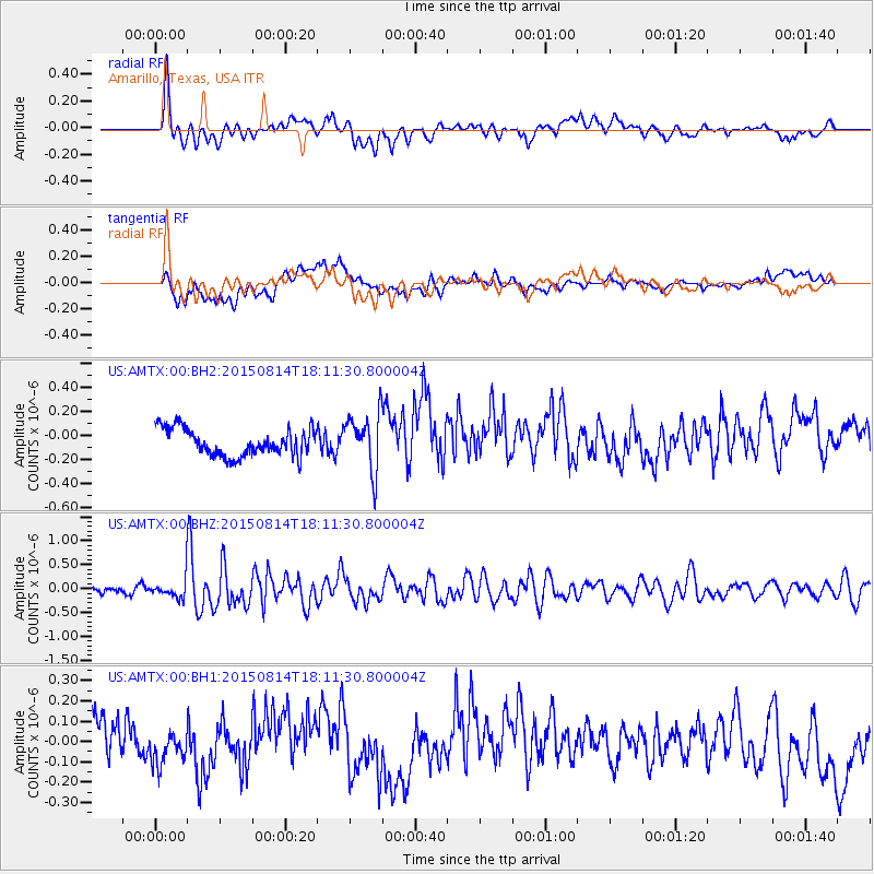
Signal To Noise
| Channel | StoN | STA | LTA |
| US:AMTX:00:BHZ:20150814T18:11:30.800004Z | 3.5024302 | 2.0914796E-7 | 5.97151E-8 |
| US:AMTX:00:BH1:20150814T18:11:30.800004Z | 0.5916985 | 7.49788E-8 | 1.2671791E-7 |
| US:AMTX:00:BH2:20150814T18:11:30.800004Z | 1.2163968 | 1.3609211E-7 | 1.1188135E-7 |
| Arrivals |
| Ps | |
| PpPs | |
| PsPs/PpSs | |


