You are here: Home > Network List > TA - USArray Transportable Network (new EarthScope stations) Stations List
> Station L20K Farewell, AK, USA > Earthquake Result Viewer
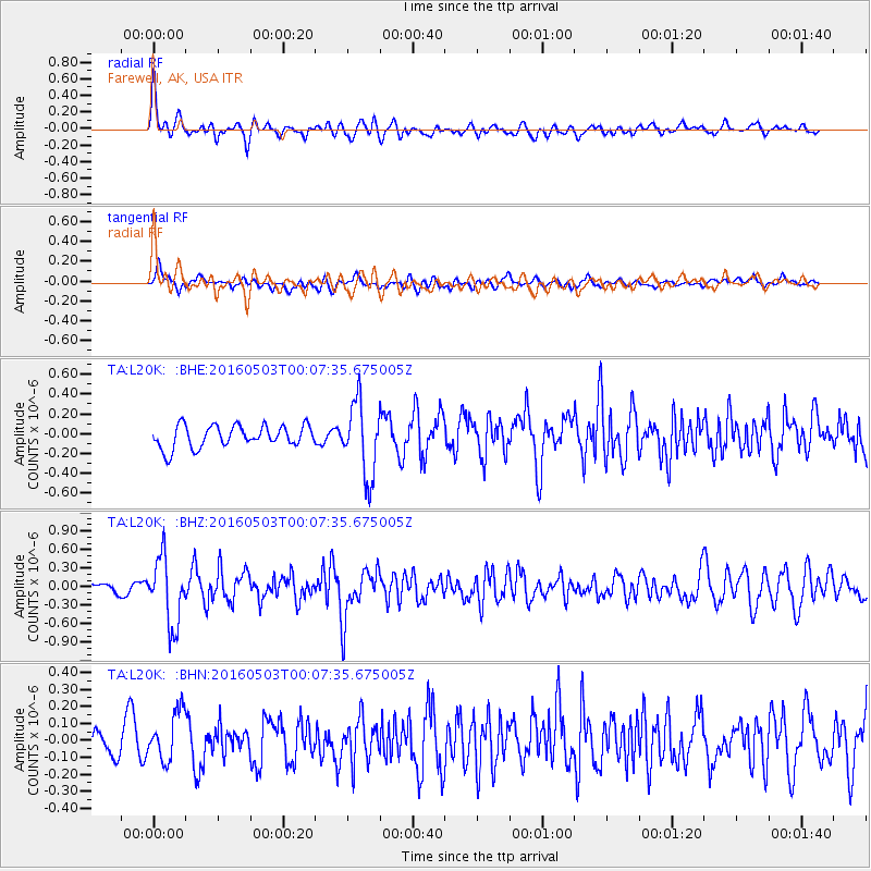
L20K Farewell, AK, USA - Earthquake Result Viewer
*The percent match for this event was below the threshold and hence no stack was calculated.
| Earthquake location: |
Kuril Islands |
| Earthquake latitude/longitude: |
43.7/147.5 |
| Earthquake time(UTC): |
2016/05/03 (124) 00:00:51 GMT |
| Earthquake Depth: |
61 km |
| Earthquake Magnitude: |
5.5 MB, 5.7 MWC, 5.7 MWB |
| Earthquake Catalog/Contributor: |
NEIC PDE/NEIC COMCAT |
|
| Network: |
TA USArray Transportable Network (new EarthScope stations) |
| Station: |
L20K Farewell, AK, USA |
| Lat/Lon: |
62.48 N/153.88 W |
| Elevation: |
673 m |
|
| Distance: |
38.3 deg |
| Az: |
39.803 deg |
| Baz: |
268.625 deg |
| Ray Param: |
$rayparam |
*The percent match for this event was below the threshold and hence was not used in the summary stack. |
|
| Radial Match: |
78.00769 % |
| Radial Bump: |
400 |
| Transverse Match: |
56.0434 % |
| Transverse Bump: |
400 |
| SOD ConfigId: |
7422571 |
| Insert Time: |
2019-04-22 12:41:26.796 +0000 |
| GWidth: |
2.5 |
| Max Bumps: |
400 |
| Tol: |
0.001 |
|
Signal To Noise
| Channel | StoN | STA | LTA |
| TA:L20K: :BHZ:20160503T00:07:35.675005Z | 6.253973 | 5.372537E-7 | 8.590599E-8 |
| TA:L20K: :BHN:20160503T00:07:35.675005Z | 1.205392 | 1.4299904E-7 | 1.1863281E-7 |
| TA:L20K: :BHE:20160503T00:07:35.675005Z | 3.3194637 | 3.7082782E-7 | 1.1171317E-7 |
| Arrivals |
| Ps | |
| PpPs | |
| PsPs/PpSs | |


