You are here: Home > Network List > TA - USArray Transportable Network (new EarthScope stations) Stations List
> Station MSTX Muleshoe, TX, USA > Earthquake Result Viewer
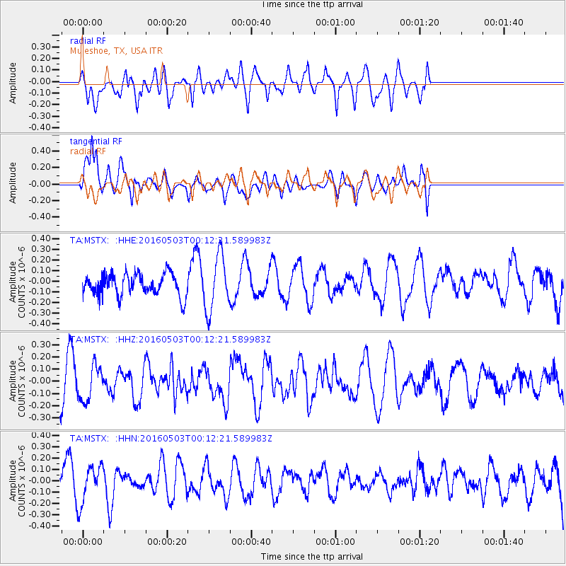
MSTX Muleshoe, TX, USA - Earthquake Result Viewer
*The percent match for this event was below the threshold and hence no stack was calculated.
| Earthquake location: |
Kuril Islands |
| Earthquake latitude/longitude: |
43.7/147.5 |
| Earthquake time(UTC): |
2016/05/03 (124) 00:00:51 GMT |
| Earthquake Depth: |
61 km |
| Earthquake Magnitude: |
5.5 MB, 5.7 MWC, 5.7 MWB |
| Earthquake Catalog/Contributor: |
NEIC PDE/NEIC COMCAT |
|
| Network: |
TA USArray Transportable Network (new EarthScope stations) |
| Station: |
MSTX Muleshoe, TX, USA |
| Lat/Lon: |
33.97 N/102.77 W |
| Elevation: |
1167 m |
|
| Distance: |
79.7 deg |
| Az: |
52.677 deg |
| Baz: |
316.04 deg |
| Ray Param: |
$rayparam |
*The percent match for this event was below the threshold and hence was not used in the summary stack. |
|
| Radial Match: |
58.587997 % |
| Radial Bump: |
400 |
| Transverse Match: |
69.99667 % |
| Transverse Bump: |
400 |
| SOD ConfigId: |
7422571 |
| Insert Time: |
2019-04-22 12:41:37.554 +0000 |
| GWidth: |
2.5 |
| Max Bumps: |
400 |
| Tol: |
0.001 |
|
Signal To Noise
| Channel | StoN | STA | LTA |
| TA:MSTX: :HHZ:20160503T00:12:21.589983Z | 1.293095 | 1.4297535E-7 | 1.1056833E-7 |
| TA:MSTX: :HHN:20160503T00:12:21.589983Z | 0.9771428 | 1.6032855E-7 | 1.6407894E-7 |
| TA:MSTX: :HHE:20160503T00:12:21.589983Z | 2.6281407 | 2.6617167E-7 | 1.0127756E-7 |
| Arrivals |
| Ps | |
| PpPs | |
| PsPs/PpSs | |


