You are here: Home > Network List > TJ - Tajikistan National Seismic Network Stations List
> Station CHGR Chuyangaron, Tajikistan > Earthquake Result Viewer
CHGR Chuyangaron, Tajikistan - Earthquake Result Viewer
| Earthquake location: |
Kuril Islands |
| Earthquake latitude/longitude: |
43.7/147.5 |
| Earthquake time(UTC): |
2016/05/03 (124) 00:00:51 GMT |
| Earthquake Depth: |
61 km |
| Earthquake Magnitude: |
5.5 MB, 5.7 MWC, 5.7 MWB |
| Earthquake Catalog/Contributor: |
NEIC PDE/NEIC COMCAT |
|
| Network: |
TJ Tajikistan National Seismic Network |
| Station: |
CHGR Chuyangaron, Tajikistan |
| Lat/Lon: |
38.66 N/69.16 E |
| Elevation: |
1049 m |
|
| Distance: |
57.1 deg |
| Az: |
294.066 deg |
| Baz: |
57.78 deg |
| Ray Param: |
0.0635408 |
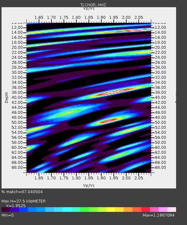
| Estimated Moho Depth: |
37.5 km |
| Estimated Crust Vp/Vs: |
1.95 |
| Assumed Crust Vp: |
6.483 km/s |
| Estimated Crust Vs: |
3.32 km/s |
| Estimated Crust Poisson's Ratio: |
0.32 |
|
| Radial Match: |
87.040504 % |
| Radial Bump: |
400 |
| Transverse Match: |
75.38169 % |
| Transverse Bump: |
400 |
| SOD ConfigId: |
7422571 |
| Insert Time: |
2019-04-22 12:41:52.010 +0000 |
| GWidth: |
2.5 |
| Max Bumps: |
400 |
| Tol: |
0.001 |
|

Signal To Noise
| Channel | StoN | STA | LTA |
| TJ:CHGR: :HHZ:20160503T00:10:01.250017Z | 19.791954 | 1.5743119E-6 | 7.954302E-8 |
| TJ:CHGR: :HHN:20160503T00:10:01.250017Z | 3.6322448 | 4.286204E-7 | 1.1800428E-7 |
| TJ:CHGR: :HHE:20160503T00:10:01.250017Z | 7.80193 | 5.6015915E-7 | 7.179751E-8 |
| Arrivals |
| Ps | 5.8 SECOND |
| PpPs | 16 SECOND |
| PsPs/PpSs | 22 SECOND |


