You are here: Home > Network List > UW - Pacific Northwest Regional Seismic Network Stations List
> Station UMAT Pilot Rock, OR, USA > Earthquake Result Viewer
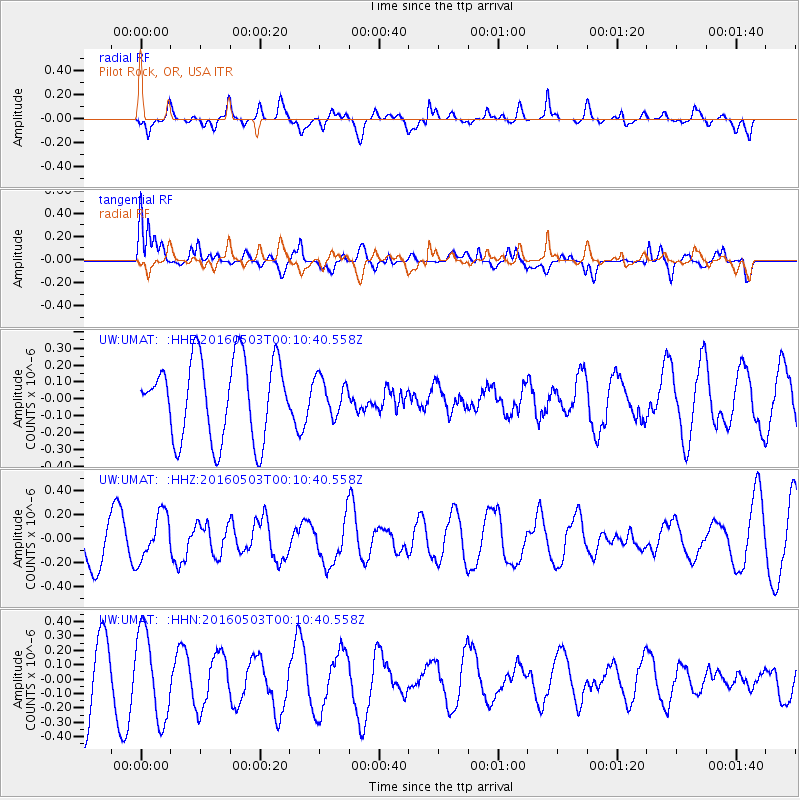
UMAT Pilot Rock, OR, USA - Earthquake Result Viewer
*The percent match for this event was below the threshold and hence no stack was calculated.
| Earthquake location: |
Kuril Islands |
| Earthquake latitude/longitude: |
43.7/147.5 |
| Earthquake time(UTC): |
2016/05/03 (124) 00:00:51 GMT |
| Earthquake Depth: |
61 km |
| Earthquake Magnitude: |
5.5 MB, 5.7 MWC, 5.7 MWB |
| Earthquake Catalog/Contributor: |
NEIC PDE/NEIC COMCAT |
|
| Network: |
UW Pacific Northwest Regional Seismic Network |
| Station: |
UMAT Pilot Rock, OR, USA |
| Lat/Lon: |
45.29 N/118.96 W |
| Elevation: |
1318 m |
|
| Distance: |
62.9 deg |
| Az: |
52.339 deg |
| Baz: |
305.556 deg |
| Ray Param: |
$rayparam |
*The percent match for this event was below the threshold and hence was not used in the summary stack. |
|
| Radial Match: |
51.791977 % |
| Radial Bump: |
400 |
| Transverse Match: |
66.97714 % |
| Transverse Bump: |
400 |
| SOD ConfigId: |
7422571 |
| Insert Time: |
2019-04-22 12:42:31.840 +0000 |
| GWidth: |
2.5 |
| Max Bumps: |
400 |
| Tol: |
0.001 |
|
Signal To Noise
| Channel | StoN | STA | LTA |
| UW:UMAT: :HHZ:20160503T00:10:40.558Z | 1.000017 | 1.8842904E-7 | 1.8842583E-7 |
| UW:UMAT: :HHN:20160503T00:10:40.558Z | 1.5012916 | 3.0368673E-7 | 2.0228363E-7 |
| UW:UMAT: :HHE:20160503T00:10:40.558Z | 0.45065922 | 1.0603516E-7 | 2.35289E-7 |
| Arrivals |
| Ps | |
| PpPs | |
| PsPs/PpSs | |


