You are here: Home > Network List > XL12 - Hangay Dome, Mongolia Stations List
> Station HV07 HV07 > Earthquake Result Viewer
HV07 HV07 - Earthquake Result Viewer
| Earthquake location: |
Kuril Islands |
| Earthquake latitude/longitude: |
43.7/147.5 |
| Earthquake time(UTC): |
2016/05/03 (124) 00:00:51 GMT |
| Earthquake Depth: |
61 km |
| Earthquake Magnitude: |
5.5 MB, 5.7 MWC, 5.7 MWB |
| Earthquake Catalog/Contributor: |
NEIC PDE/NEIC COMCAT |
|
| Network: |
XL Hangay Dome, Mongolia |
| Station: |
HV07 HV07 |
| Lat/Lon: |
51.11 N/99.67 E |
| Elevation: |
1568 m |
|
| Distance: |
32.7 deg |
| Az: |
300.203 deg |
| Baz: |
84.071 deg |
| Ray Param: |
0.07838817 |
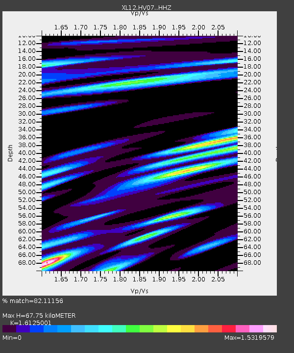
| Estimated Moho Depth: |
67.75 km |
| Estimated Crust Vp/Vs: |
1.61 |
| Assumed Crust Vp: |
6.622 km/s |
| Estimated Crust Vs: |
4.107 km/s |
| Estimated Crust Poisson's Ratio: |
0.19 |
|
| Radial Match: |
82.11156 % |
| Radial Bump: |
400 |
| Transverse Match: |
57.752617 % |
| Transverse Bump: |
400 |
| SOD ConfigId: |
7422571 |
| Insert Time: |
2019-04-22 12:43:14.187 +0000 |
| GWidth: |
2.5 |
| Max Bumps: |
400 |
| Tol: |
0.001 |
|

Signal To Noise
| Channel | StoN | STA | LTA |
| XL:HV07: :HHZ:20160503T00:06:48.219988Z | 13.668341 | 4.818187E-7 | 3.5250707E-8 |
| XL:HV07: :HHN:20160503T00:06:48.219988Z | 2.1926124 | 9.070169E-8 | 4.1366953E-8 |
| XL:HV07: :HHE:20160503T00:06:48.219988Z | 10.077337 | 3.1643745E-7 | 3.1400898E-8 |
| Arrivals |
| Ps | 6.9 SECOND |
| PpPs | 24 SECOND |
| PsPs/PpSs | 31 SECOND |


