You are here: Home > Network List > XL12 - Hangay Dome, Mongolia Stations List
> Station HV15 HV15 > Earthquake Result Viewer
HV15 HV15 - Earthquake Result Viewer
| Earthquake location: |
Kuril Islands |
| Earthquake latitude/longitude: |
43.7/147.5 |
| Earthquake time(UTC): |
2016/05/03 (124) 00:00:51 GMT |
| Earthquake Depth: |
61 km |
| Earthquake Magnitude: |
5.5 MB, 5.7 MWC, 5.7 MWB |
| Earthquake Catalog/Contributor: |
NEIC PDE/NEIC COMCAT |
|
| Network: |
XL Hangay Dome, Mongolia |
| Station: |
HV15 HV15 |
| Lat/Lon: |
50.11 N/100.06 E |
| Elevation: |
1569 m |
|
| Distance: |
32.6 deg |
| Az: |
298.308 deg |
| Baz: |
82.778 deg |
| Ray Param: |
0.07844903 |
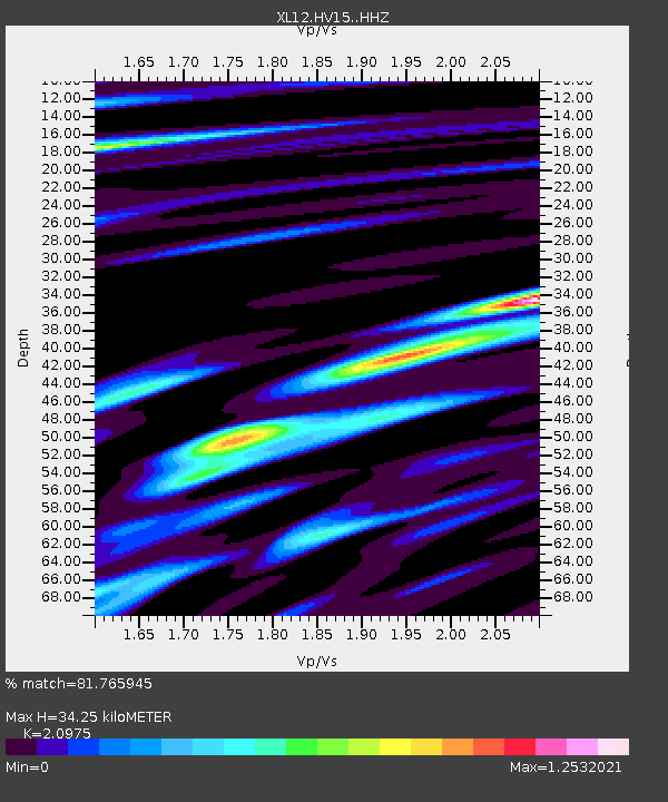
| Estimated Moho Depth: |
34.25 km |
| Estimated Crust Vp/Vs: |
2.10 |
| Assumed Crust Vp: |
6.419 km/s |
| Estimated Crust Vs: |
3.06 km/s |
| Estimated Crust Poisson's Ratio: |
0.35 |
|
| Radial Match: |
81.765945 % |
| Radial Bump: |
388 |
| Transverse Match: |
67.79688 % |
| Transverse Bump: |
400 |
| SOD ConfigId: |
7422571 |
| Insert Time: |
2019-04-22 12:43:19.019 +0000 |
| GWidth: |
2.5 |
| Max Bumps: |
400 |
| Tol: |
0.001 |
|

Signal To Noise
| Channel | StoN | STA | LTA |
| XL:HV15: :HHZ:20160503T00:06:47.048998Z | 11.25739 | 4.269472E-7 | 3.7925947E-8 |
| XL:HV15: :HHN:20160503T00:06:47.048998Z | 2.6078916 | 9.160198E-8 | 3.512492E-8 |
| XL:HV15: :HHE:20160503T00:06:47.048998Z | 12.368336 | 2.4615767E-7 | 1.9902247E-8 |
| Arrivals |
| Ps | 6.3 SECOND |
| PpPs | 15 SECOND |
| PsPs/PpSs | 22 SECOND |


