You are here: Home > Network List > US - United States National Seismic Network Stations List
> Station SCIA State Center, Iowa, USA > Earthquake Result Viewer
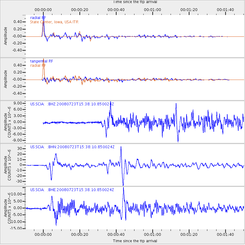
SCIA State Center, Iowa, USA - Earthquake Result Viewer
| Earthquake location: |
Eastern Honshu, Japan |
| Earthquake latitude/longitude: |
39.8/141.5 |
| Earthquake time(UTC): |
2008/07/23 (205) 15:26:19 GMT |
| Earthquake Depth: |
108 km |
| Earthquake Magnitude: |
6.6 MB, 6.8 MW, 6.8 MW |
| Earthquake Catalog/Contributor: |
WHDF/NEIC |
|
| Network: |
US United States National Seismic Network |
| Station: |
SCIA State Center, Iowa, USA |
| Lat/Lon: |
41.91 N/93.22 W |
| Elevation: |
312 m |
|
| Distance: |
84.7 deg |
| Az: |
37.708 deg |
| Baz: |
320.859 deg |
| Ray Param: |
0.045036238 |
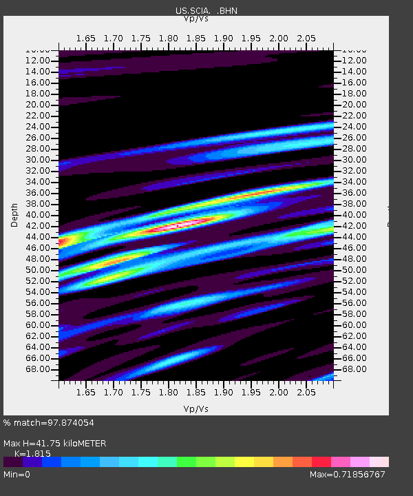
| Estimated Moho Depth: |
41.75 km |
| Estimated Crust Vp/Vs: |
1.82 |
| Assumed Crust Vp: |
6.498 km/s |
| Estimated Crust Vs: |
3.58 km/s |
| Estimated Crust Poisson's Ratio: |
0.28 |
|
| Radial Match: |
97.874054 % |
| Radial Bump: |
306 |
| Transverse Match: |
89.24616 % |
| Transverse Bump: |
400 |
| SOD ConfigId: |
2504 |
| Insert Time: |
2010-03-05 02:50:42.040 +0000 |
| GWidth: |
2.5 |
| Max Bumps: |
400 |
| Tol: |
0.001 |
|
Signal To Noise
| Channel | StoN | STA | LTA |
| US:SCIA: :BHN:20080723T15:38:10.850024Z | 54.870758 | 9.182332E-6 | 1.6734472E-7 |
| US:SCIA: :BHE:20080723T15:38:10.850024Z | 13.782889 | 2.5991417E-6 | 1.8857742E-7 |
| US:SCIA: :BHZ:20080723T15:38:10.850024Z | 11.379629 | 2.067743E-6 | 1.8170564E-7 |
| Arrivals |
| Ps | 5.4 SECOND |
| PpPs | 18 SECOND |
| PsPs/PpSs | 23 SECOND |


