You are here: Home > Network List > TM - Thai Seismic Monitoring Network Stations List
> Station LOEI LOEI staion > Earthquake Result Viewer
LOEI LOEI staion - Earthquake Result Viewer
| Earthquake location: |
Eastern Gulf Of Aden |
| Earthquake latitude/longitude: |
13.8/51.8 |
| Earthquake time(UTC): |
2016/05/05 (126) 07:01:47 GMT |
| Earthquake Depth: |
10 km |
| Earthquake Magnitude: |
5.5 MWB, 5.6 MWC |
| Earthquake Catalog/Contributor: |
NEIC PDE/NEIC COMCAT |
|
| Network: |
TM Thai Seismic Monitoring Network |
| Station: |
LOEI LOEI staion |
| Lat/Lon: |
17.51 N/101.62 E |
| Elevation: |
305 m |
|
| Distance: |
48.0 deg |
| Az: |
78.757 deg |
| Baz: |
272.961 deg |
| Ray Param: |
0.06960521 |
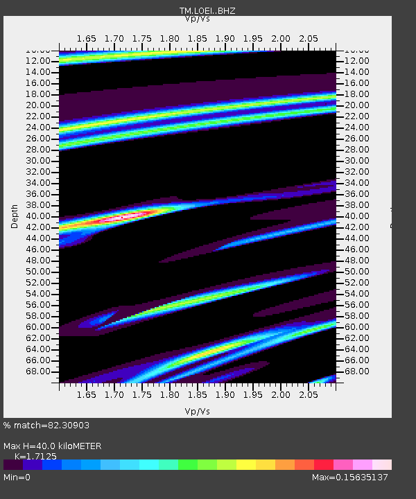
| Estimated Moho Depth: |
40.0 km |
| Estimated Crust Vp/Vs: |
1.71 |
| Assumed Crust Vp: |
6.35 km/s |
| Estimated Crust Vs: |
3.708 km/s |
| Estimated Crust Poisson's Ratio: |
0.24 |
|
| Radial Match: |
82.30903 % |
| Radial Bump: |
113 |
| Transverse Match: |
74.236374 % |
| Transverse Bump: |
400 |
| SOD ConfigId: |
7422571 |
| Insert Time: |
2019-04-22 12:57:54.028 +0000 |
| GWidth: |
2.5 |
| Max Bumps: |
400 |
| Tol: |
0.001 |
|

Signal To Noise
| Channel | StoN | STA | LTA |
| TM:LOEI: :BHZ:20160505T07:09:55.940012Z | 1.1922885 | 1.3202147E-6 | 1.1072947E-6 |
| TM:LOEI: :BHN:20160505T07:09:55.940012Z | 2.4550216 | 1.8172644E-6 | 7.4022336E-7 |
| TM:LOEI: :BHE:20160505T07:09:55.940012Z | 1.1358688 | 6.302572E-7 | 5.54868E-7 |
| Arrivals |
| Ps | 4.8 SECOND |
| PpPs | 16 SECOND |
| PsPs/PpSs | 21 SECOND |


