You are here: Home > Network List > WY - Yellowstone Wyoming Seismic Network Stations List
> Station YHR Hawk's Rest, WY, USA > Earthquake Result Viewer
YHR Hawk's Rest, WY, USA - Earthquake Result Viewer
*The percent match for this event was below the threshold and hence no stack was calculated.
| Earthquake location: |
Northern Mid-Atlantic Ridge |
| Earthquake latitude/longitude: |
21.1/-45.9 |
| Earthquake time(UTC): |
2015/08/14 (226) 18:03:03 GMT |
| Earthquake Depth: |
13 km |
| Earthquake Magnitude: |
5.5 MB |
| Earthquake Catalog/Contributor: |
NEIC PDE/NEIC COMCAT |
|
| Network: |
WY Yellowstone Wyoming Seismic Network |
| Station: |
YHR Hawk's Rest, WY, USA |
| Lat/Lon: |
44.11 N/110.08 W |
| Elevation: |
2976 m |
|
| Distance: |
57.2 deg |
| Az: |
309.534 deg |
| Baz: |
91.624 deg |
| Ray Param: |
$rayparam |
*The percent match for this event was below the threshold and hence was not used in the summary stack. |
|
| Radial Match: |
46.231403 % |
| Radial Bump: |
400 |
| Transverse Match: |
22.378675 % |
| Transverse Bump: |
400 |
| SOD ConfigId: |
1085051 |
| Insert Time: |
2015-08-28 18:50:11.468 +0000 |
| GWidth: |
2.5 |
| Max Bumps: |
400 |
| Tol: |
0.001 |
|
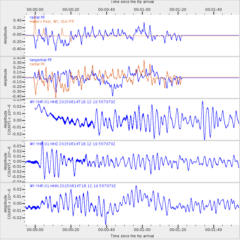
Signal To Noise
| Channel | StoN | STA | LTA |
| WY:YHR:01:HHZ:20150814T18:12:19.567979Z | 5.472297 | 1.4224859E-8 | 2.599431E-9 |
| WY:YHR:01:HHN:20150814T18:12:19.567979Z | 0.67588156 | 7.568155E-9 | 1.1197457E-8 |
| WY:YHR:01:HHE:20150814T18:12:19.567979Z | 1.4231805 | 1.10729035E-8 | 7.780393E-9 |
| Arrivals |
| Ps | |
| PpPs | |
| PsPs/PpSs | |


