You are here: Home > Network List > TA - USArray Transportable Network (new EarthScope stations) Stations List
> Station Z41A Richland Creek Farm, El Dorado, AR, USA > Earthquake Result Viewer
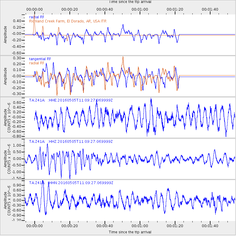
Z41A Richland Creek Farm, El Dorado, AR, USA - Earthquake Result Viewer
*The percent match for this event was below the threshold and hence no stack was calculated.
| Earthquake location: |
Central East Pacific Rise |
| Earthquake latitude/longitude: |
-8.9/-108.2 |
| Earthquake time(UTC): |
2016/05/05 (126) 11:01:46 GMT |
| Earthquake Depth: |
10 km |
| Earthquake Magnitude: |
5.6 mwb |
| Earthquake Catalog/Contributor: |
NEIC PDE/us |
|
| Network: |
TA USArray Transportable Network (new EarthScope stations) |
| Station: |
Z41A Richland Creek Farm, El Dorado, AR, USA |
| Lat/Lon: |
33.26 N/92.80 W |
| Elevation: |
62 m |
|
| Distance: |
44.5 deg |
| Az: |
18.566 deg |
| Baz: |
202.051 deg |
| Ray Param: |
$rayparam |
*The percent match for this event was below the threshold and hence was not used in the summary stack. |
|
| Radial Match: |
49.845108 % |
| Radial Bump: |
397 |
| Transverse Match: |
66.07767 % |
| Transverse Bump: |
304 |
| SOD ConfigId: |
7422571 |
| Insert Time: |
2019-04-22 13:05:46.152 +0000 |
| GWidth: |
2.5 |
| Max Bumps: |
400 |
| Tol: |
0.001 |
|
Signal To Noise
| Channel | StoN | STA | LTA |
| TA:Z41A: :HHZ:20160505T11:09:27.069999Z | 2.811279 | 4.3145502E-7 | 1.5347285E-7 |
| TA:Z41A: :HHN:20160505T11:09:27.069999Z | 1.8433883 | 5.226077E-7 | 2.8350388E-7 |
| TA:Z41A: :HHE:20160505T11:09:27.069999Z | 1.100244 | 2.622573E-7 | 2.3836283E-7 |
| Arrivals |
| Ps | |
| PpPs | |
| PsPs/PpSs | |


