You are here: Home > Network List > US - United States National Seismic Network Stations List
> Station DGMT Dagmar, Montana, USA > Earthquake Result Viewer
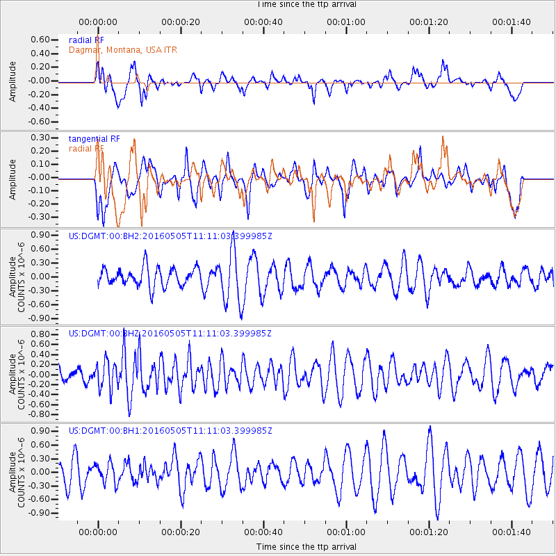
DGMT Dagmar, Montana, USA - Earthquake Result Viewer
*The percent match for this event was below the threshold and hence no stack was calculated.
| Earthquake location: |
Central East Pacific Rise |
| Earthquake latitude/longitude: |
-8.9/-108.2 |
| Earthquake time(UTC): |
2016/05/05 (126) 11:01:46 GMT |
| Earthquake Depth: |
10 km |
| Earthquake Magnitude: |
5.6 mwb |
| Earthquake Catalog/Contributor: |
NEIC PDE/us |
|
| Network: |
US United States National Seismic Network |
| Station: |
DGMT Dagmar, Montana, USA |
| Lat/Lon: |
48.47 N/104.20 W |
| Elevation: |
0.0 m |
|
| Distance: |
57.3 deg |
| Az: |
3.198 deg |
| Baz: |
184.751 deg |
| Ray Param: |
$rayparam |
*The percent match for this event was below the threshold and hence was not used in the summary stack. |
|
| Radial Match: |
49.77155 % |
| Radial Bump: |
400 |
| Transverse Match: |
43.82371 % |
| Transverse Bump: |
400 |
| SOD ConfigId: |
7422571 |
| Insert Time: |
2019-04-22 13:06:09.933 +0000 |
| GWidth: |
2.5 |
| Max Bumps: |
400 |
| Tol: |
0.001 |
|
Signal To Noise
| Channel | StoN | STA | LTA |
| US:DGMT:00:BHZ:20160505T11:11:03.399985Z | 1.1580236 | 2.773316E-7 | 2.39487E-7 |
| US:DGMT:00:BH1:20160505T11:11:03.399985Z | 0.56147105 | 2.2203632E-7 | 3.9545463E-7 |
| US:DGMT:00:BH2:20160505T11:11:03.399985Z | 2.912141 | 5.727814E-7 | 1.9668738E-7 |
| Arrivals |
| Ps | |
| PpPs | |
| PsPs/PpSs | |


