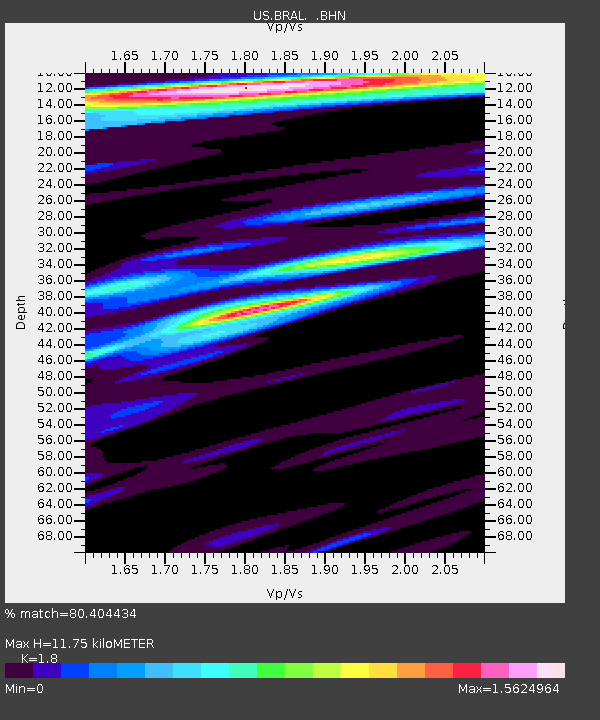
BRAL Brewton, Alabama, USA - Earthquake Result Viewer
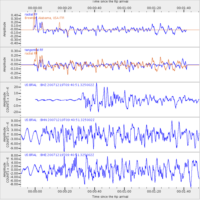
Earthquake location: Andreanof Islands, Aleutian Is.
Earthquake latitude/longitude: 51.4/-179.5
Earthquake time(UTC): 2007/12/19 (353) 09:30:27 GMT
Earthquake Depth: 29 km
Earthquake Magnitude: 6.4 MB, 7.1 MS, 7.1 MW, 7.0 MW
Earthquake Catalog/Contributor: WHDF/NEIC
Network: US United States National Seismic Network
Station: BRAL Brewton, Alabama, USA
Lat/Lon: 31.01 N/87.06 W
Elevation: 61 m
Distance: 67.9 deg
Az: 67.793 deg
Baz: 317.465 deg
Ray Param: 0.056613833
Estimated Moho Depth: 11.75 km
Estimated Crust Vp/Vs: 1.80
Assumed Crust Vp: 6.187 km/s
Estimated Crust Vs: 3.437 km/s
Estimated Crust Poisson's Ratio: 0.28
Radial Match: 80.404434 %
Radial Bump: 400
Transverse Match: 67.832695 %
Transverse Bump: 400
SOD ConfigId: 2564
Insert Time: 2010-03-05 02:56:53.523 +0000
GWidth: 2.5
Max Bumps: 400
Tol: 0.001

Signal To Noise

ChannelStoNSTALTA
US:BRAL: :BHN:20071219T09:40:51.325002Z2.15400673.0804633E-61.4301086E-6
US:BRAL: :BHE:20071219T09:40:51.325002Z1.73244021.7902939E-61.0333944E-6
US:BRAL: :BHZ:20071219T09:40:51.325002Z10.9749576.5194777E-65.9403214E-7
Arrivals
Ps1.6 SECOND
PpPs5.1 SECOND
PsPs/PpSs6.7 SECOND