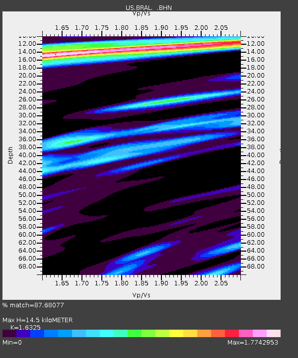
BRAL Brewton, Alabama, USA - Earthquake Result Viewer
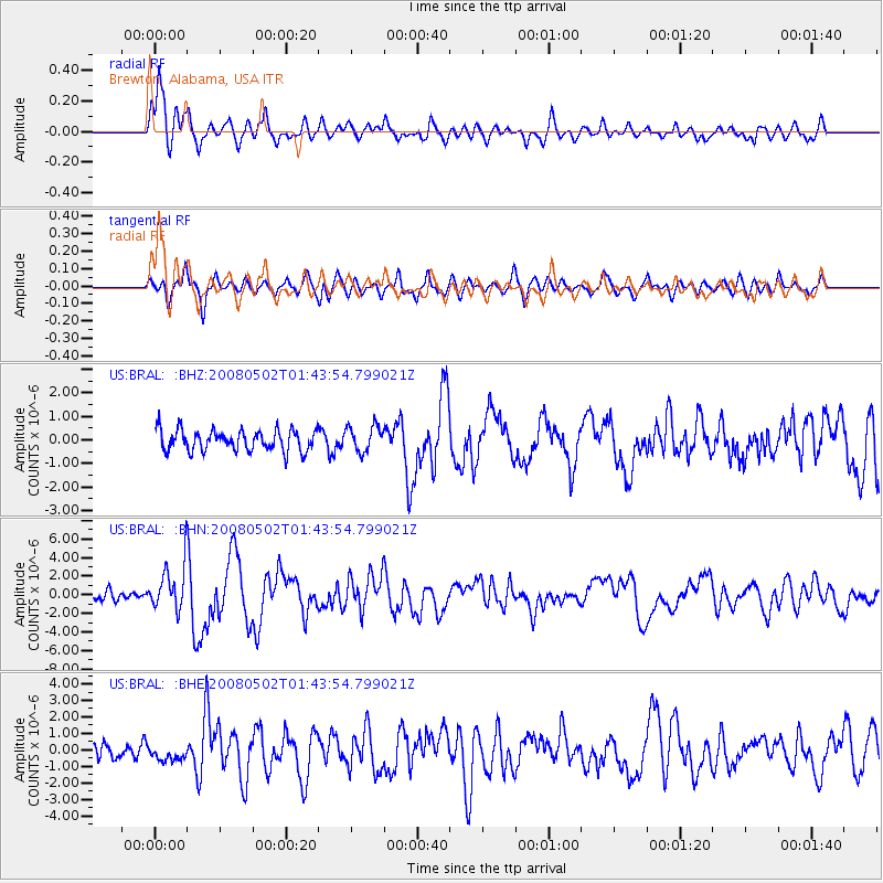
Earthquake location: Andreanof Islands, Aleutian Is.
Earthquake latitude/longitude: 51.9/-177.5
Earthquake time(UTC): 2008/05/02 (123) 01:33:37 GMT
Earthquake Depth: 14 km
Earthquake Magnitude: 6.3 MB, 6.8 MS, 6.6 MW, 6.6 MW
Earthquake Catalog/Contributor: WHDF/NEIC
Network: US United States National Seismic Network
Station: BRAL Brewton, Alabama, USA
Lat/Lon: 31.01 N/87.06 W
Elevation: 61 m
Distance: 66.6 deg
Az: 69.357 deg
Baz: 317.479 deg
Ray Param: 0.057528727
Estimated Moho Depth: 14.5 km
Estimated Crust Vp/Vs: 1.63
Assumed Crust Vp: 6.187 km/s
Estimated Crust Vs: 3.79 km/s
Estimated Crust Poisson's Ratio: 0.20
Radial Match: 87.68077 %
Radial Bump: 400
Transverse Match: 72.94162 %
Transverse Bump: 400
SOD ConfigId: 2504
Insert Time: 2010-03-05 02:56:55.478 +0000
GWidth: 2.5
Max Bumps: 400
Tol: 0.001

Signal To Noise

ChannelStoNSTALTA
US:BRAL: :BHN:20080502T01:43:54.799021Z3.8450982.5613037E-66.661218E-7
US:BRAL: :BHE:20080502T01:43:54.799021Z0.92179144.3930697E-74.765796E-7
US:BRAL: :BHZ:20080502T01:43:54.799021Z1.24118015.3517937E-74.3118595E-7
Arrivals
Ps1.5 SECOND
PpPs5.9 SECOND
PsPs/PpSs7.5 SECOND