You are here: Home > Network List > CI - Caltech Regional Seismic Network Stations List
> Station NEE2 Needles Airport > Earthquake Result Viewer
NEE2 Needles Airport - Earthquake Result Viewer

| Earthquake location: |
Kuril Islands |
| Earthquake latitude/longitude: |
47.7/154.5 |
| Earthquake time(UTC): |
2006/11/15 (319) 21:35:09 GMT |
| Earthquake Depth: |
10 km |
| Earthquake Magnitude: |
5.6 MB |
| Earthquake Catalog/Contributor: |
WHDF/NEIC |
|
| Network: |
CI Caltech Regional Seismic Network |
| Station: |
NEE2 Needles Airport |
| Lat/Lon: |
34.77 N/114.62 W |
| Elevation: |
271 m |
|
| Distance: |
65.8 deg |
| Az: |
64.507 deg |
| Baz: |
312.176 deg |
| Ray Param: |
0.058048144 |
| Estimated Moho Depth: |
10.0 km |
| Estimated Crust Vp/Vs: |
1.60 |
| Assumed Crust Vp: |
6.276 km/s |
| Estimated Crust Vs: |
3.922 km/s |
| Estimated Crust Poisson's Ratio: |
0.18 |
|
| Radial Match: |
99.92604 % |
| Radial Bump: |
5 |
| Transverse Match: |
99.74138 % |
| Transverse Bump: |
23 |
| SOD ConfigId: |
2564 |
| Insert Time: |
2010-02-26 00:20:52.648 +0000 |
| GWidth: |
2.5 |
| Max Bumps: |
400 |
| Tol: |
0.001 |
|
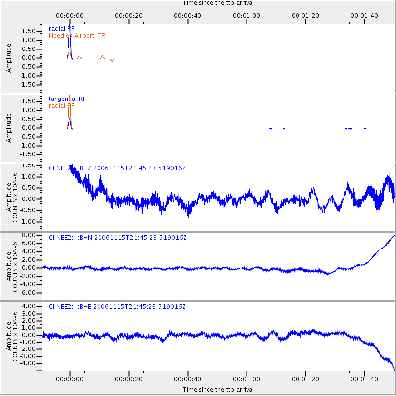
Signal To Noise
| Channel | StoN | STA | LTA |
| CI:NEE2: :BHN:20061115T21:45:23.519016Z | 0.9372334 | 6.378529E-7 | 6.8056994E-7 |
| CI:NEE2: :BHE:20061115T21:45:23.519016Z | 0.72655416 | 4.2730673E-7 | 5.881278E-7 |
| CI:NEE2: :BHZ:20061115T21:45:23.519016Z | 1.0010456 | 5.080157E-7 | 5.074851E-7 |
| Arrivals |
| Ps | 1.0 SECOND |
| PpPs | 4.0 SECOND |
| PsPs/PpSs | 5.0 SECOND |


